Yunguyo geodata
Yunguyo (Puno) is a seat of a third-order administrative division; located in Peru in America/Lima (GMT-5) time zone. With population of 16,140 people, there are 97 cities with bigger population in this country. Compared to other cities in Peru, 94.6% of cities are located further ↑North; 99.9% of cities are located further ←West and 90.4% of cities have lower elevation than Yunguyo. Note1


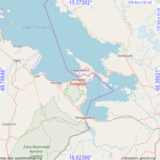
Yunguyo GPS coordinates[2]
16° 15' 0" South, 69° 4' 59.988" West
| Map corner | latitude | longitude |
|---|---|---|
| Upper-left | -15.57382°, | -69.78646° |
| Center: | -16.25°, | -69.08333° |
| Lower-right: | -16.92386°, | -68.38021° |
| Map W x H: | 150.1×150.1 km | = 93.3×93.3mi |
| max Lat: | -0.96667° ⇑94.6% North |
| Yunguyo: | -16.25° |
| min Lat: | ⇓5.4% South -18.01465° |
| min Long | Yunguyo | max Long |
| -81.30472° | -69.08333° | -69.04167° |
| W 99.9%⇐ | ⇒0.099999999999994% E |
Elevation
Elevation of Yunguyo is 3857 m = 12654 ft, and this is 1538.3 m = 5047 ft above average elevation for this country.
| Max E: |
5022 m = 16476 ft | 9.6% |
| Yunguyo | 3857 m 12654 ft | |
| Avg. | 2318.7 m = 7607 ft | |
Min E: |
1 m = 3 ft | 90.4% |
See also: Peru elevation on elevation.city.
Geographical zone
Yunguyo is located in South Torrid zone (between Equator and Tropic of Capricorn). Distance of this Southern Tropic circle is 799.1 km =496.5 mi to South.| Distance of | km | miles | from Yunguyo |
|---|---|---|---|
| Equator | 1806.8 | 1122.7 | to North |
| Tropic Capricorn | 799.1 | 496.5 | to South |
| Antarctic Circle | 5594.3 | 3476.1 | to South |
| South Pole | 8200.2 | 5095.4 | to South |


Nearby cities:
15 places around Yunguyo: (largest is in red/bold)
• Capachica
104.2 km =64.7 mi,  311°
311°
• Conima
98.2 km =61 mi,  337°
337°
• Desaguadero
35.4 km =22 mi,  172°
172°
• Huayrapata
109 km =67.7 mi,  345°
345°
• Ilave
65 km =40.4 mi,  286°
286°
• Juli
39.3 km =24.4 mi,  275°
275°
• Kelluyo
55.8 km =34.7 mi,  199°
199°
• Laraqueri
104 km =64.6 mi, 277°
• Mazo Cruz
88.8 km =55.2 mi,  231°
231°
• Moho
109.6 km =68.1 mi, 335°
• Pilcuyo
54.2 km =33.7 mi, 287°
• Pomata
23.2 km =14.4 mi,  265°
265°
• Putina
93.8 km =58.3 mi, 336°
• Taquile
83.7 km =52 mi, 309°
• Zepita
27.9 km =17.3 mi,  183°
183°
Sources, notices
• [Note1] Compared only with cities in Peru existing in our database
• [Src1] Map data: © OpenStreetMap contributors (CC-BY-SA)
• [Src2] Other city data from geonames.org with taken over terms of usage.
• [Src3] Geographical zone / Annual Mean Temperature by Robert A. Rohde @ Wikipedia
