Juli geodata
Juli (Puno) is a seat of a third-order administrative division; located in Peru in America/Lima (GMT-5) time zone. With population of 7,309 people, there are 182 cities with bigger population in this country. Compared to other cities in Peru, 94.4% of cities are located further ↑North; 98.7% of cities are located further ←West and 94.2% of cities have lower elevation than Juli. Note1


Juli GPS coordinates[2]
16° 13' 0.012" South, 69° 27' 0" West
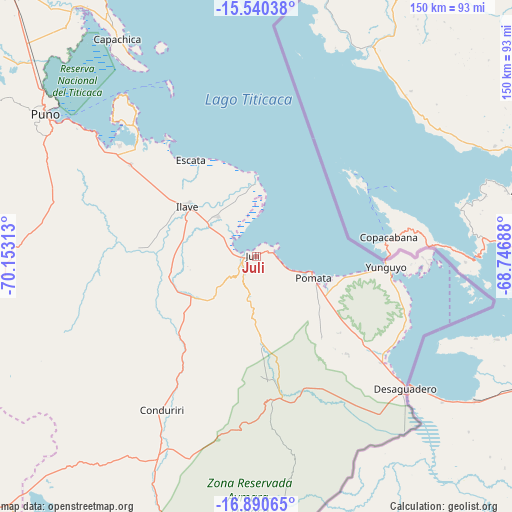
| Map corner | latitude | longitude |
|---|---|---|
| Upper-left | -15.54038°, | -70.15313° |
| Center: | -16.21667°, | -69.45° |
| Lower-right: | -16.89065°, | -68.74688° |
| Map W x H: | 150.1×150.1 km | = 93.3×93.3mi |
| max Lat: | -0.96667° ⇑94.4% North |
| Juli: | -16.21667° |
| min Lat: | ⇓5.6% South -18.01465° |
| min Long | Juli | max Long |
| -81.30472° | -69.45° | -69.04167° |
| W 98.7%⇐ | ⇒1.3% E |
Elevation
Elevation of Juli is 3980 m = 13058 ft, and this is 1661.3 m = 5450 ft above average elevation for this country.
| Max E: |
5022 m = 16476 ft | 5.8% |
| Juli | 3980 m 13058 ft | |
| Avg. | 2318.7 m = 7607 ft | |
Min E: |
1 m = 3 ft | 94.2% |
See also: Peru elevation on elevation.city.
Geographical zone
Juli is located in South Torrid zone (between Equator and Tropic of Capricorn). Distance of this Southern Tropic circle is 802.8 km =498.8 mi to South.| Distance of | km | miles | from Juli |
|---|---|---|---|
| Equator | 1803.1 | 1120.4 | to North |
| Tropic Capricorn | 802.8 | 498.8 | to South |
| Antarctic Circle | 5598 | 3478.4 | to South |
| South Pole | 8203.9 | 5097.7 | to South |


Nearby cities:
15 places around Juli: (largest is in red/bold)
• Capachica
75.8 km =47.1 mi,  328°
328°
• Desaguadero
58.3 km =36.2 mi,  131°
131°
• Huata
86.6 km =53.8 mi,  320°
320°
• Ilave
27.5 km =17.1 mi,  302°
302°
• Kelluyo
60.1 km =37.3 mi,  159°
159°
• Laraqueri
64.7 km =40.2 mi,  278°
278°
• Mazo Cruz
66.6 km =41.4 mi,  206°
206°
• Paucarcolla
83.7 km =52 mi,  309°
309°
• Pilcuyo
18 km =11.2 mi, 316°
• Pomata
17 km =10.6 mi,  109°
109°
• Puno
73.8 km =45.9 mi, 304°
• Putina
82.3 km =51.1 mi,  1°
1°
• Taquile
55.9 km =34.7 mi, 333°
• Yunguyo
39.3 km =24.4 mi,  95°
95°
• Zepita
48.9 km =30.4 mi, 130°
Sources, notices
• [Note1] Compared only with cities in Peru existing in our database
• [Src1] Map data: © OpenStreetMap contributors (CC-BY-SA)
• [Src2] Other city data from geonames.org with taken over terms of usage.
• [Src3] Geographical zone / Annual Mean Temperature by Robert A. Rohde @ Wikipedia
