Vizal Santo Niño geodata
Vizal Santo Niño (Central Luzon) is a populated place; located in Philippines in Asia/Manila (GMT+8) time zone. With population of 2,529 people, there are 3244 cities with bigger population in this country. Compared to other cities in Philippines, 77.9% of cities are located further ↓South; 79.3% of cities are located further →East and 65.1% of cities have higher elevation than Vizal Santo Niño. Note1


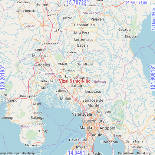
Vizal Santo Niño GPS coordinates[2]
15° 1' 45.264" North, 120° 54' 18.18" East
| Map corner | latitude | longitude |
|---|---|---|
| Upper-left | 15.70722°, | 120.20193° |
| Center: | 15.02924°, | 120.90505° |
| Lower-right: | 14.3491°, | 121.60818° |
| Map W x H: | 151×151 km | = 93.8×93.8mi |
| max Lat: | 20.78733° ⇑22.1% North |
| Vizal Santo Niño: | 15.02924° |
| min Lat: | ⇓77.9% South 4.65442° |
| min Long | Vizal Santo Ni� | max Long |
| 117.04868° | 120.90505° | 126.58417° |
| W 20.7%⇐ | ⇒79.3% E |
Elevation
Elevation of Vizal Santo Niño is 14 m = 46 ft, and this is 73.9 m = 242 ft below average elevation for this country.
| Max E: |
2262 m = 7421 ft | 65.1% |
| Avg. | 87.9 m = 288 ft | |
| Vizal Santo Niño | 14 m = 46 ft | |
Min E: |
-2 m = -7 ft | 34.9% |
See also: Philippines elevation on elevation.city.
Geographical zone
Vizal Santo Niño is located in North Torrid zone (between Equator and Tropic of Cancer). Distance of this Northern Tropic circle is 934.8 km =580.9 mi to North.| Distance of | km | miles | from Vizal Santo Niño |
|---|---|---|---|
| North Pole | 8336 | 5179.7 | to North |
| Arctic Circle | 5730.1 | 3560.5 | to North |
| Tropic Cancer | 934.8 | 580.9 | to North |
| Equator | 1671.1 | 1038.4 | to South |


Nearby cities:
15 places around Vizal Santo Niño: (largest is in red/bold)
• Bahay Pare
2.6 km =1.6 mi,  277°
277°
• Baliuag
8.3 km =5.2 mi,  186°
186°
• Bustos
8 km =5 mi,  170°
170°
• Diliman Primero
5.1 km =3.2 mi,  95°
95°
• Lourdes
5.9 km =3.7 mi,  259°
259°
• Maguinao
3.2 km =2 mi, 103°
• Mapaniqui
8.9 km =5.5 mi,  12°
12°
• Pantubig
8.6 km =5.3 mi,  141°
141°
• San Ildefonso
6.9 km =4.3 mi,  33°
33°
• San Isidro
9.2 km =5.7 mi, 264°
• San Rafael
10.9 km =6.8 mi,  145°
145°
• San Roque
4.2 km =2.6 mi,  121°
121°
• Talang
7.2 km =4.5 mi,  266°
266°
• Upig
9.3 km =5.8 mi,  92°
92°
• Vizal San Pablo
3.7 km =2.3 mi,  351°
351°
Sources, notices
• [Note1] Compared only with cities in Philippines existing in our database
• [Src1] Map data: © OpenStreetMap contributors (CC-BY-SA)
• [Src2] Other city data from geonames.org with taken over terms of usage.
• [Src3] Geographical zone / Annual Mean Temperature by Robert A. Rohde @ Wikipedia
