Maguinao geodata
Maguinao (Central Luzon) is a populated place; located in Philippines in Asia/Manila (GMT+8) time zone. With population of 2,978 people, there are 2554 cities with bigger population in this country. Compared to other cities in Philippines, 77.7% of cities are located further ↓South; 78.4% of cities are located further →East and 50.3% of cities have higher elevation than Maguinao. Note1


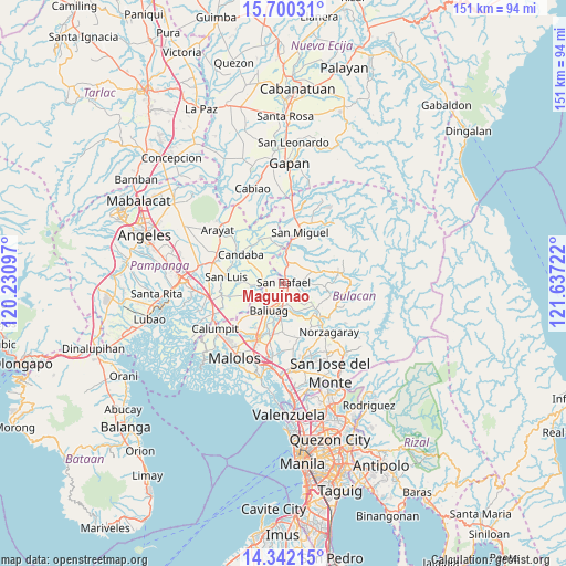
Maguinao GPS coordinates[2]
15° 1' 20.316" North, 120° 56' 2.724" East
| Map corner | latitude | longitude |
|---|---|---|
| Upper-left | 15.70031°, | 120.23097° |
| Center: | 15.02231°, | 120.93409° |
| Lower-right: | 14.34215°, | 121.63722° |
| Map W x H: | 151×151 km | = 93.8×93.8mi |
| max Lat: | 20.78733° ⇑22.3% North |
| Maguinao: | 15.02231° |
| min Lat: | ⇓77.7% South 4.65442° |
| min Long | Maguinao | max Long |
| 117.04868° | 120.93409° | 126.58417° |
| W 21.6%⇐ | ⇒78.4% E |
Elevation
Elevation of Maguinao is 23 m = 75 ft, and this is 64.9 m = 213 ft below average elevation for this country.
| Max E: |
2262 m = 7421 ft | 50.3% |
| Avg. | 87.9 m = 288 ft | |
| Maguinao | 23 m = 75 ft | |
Min E: |
-2 m = -7 ft | 49.7% |
See also: Philippines elevation on elevation.city.
Geographical zone
Maguinao is located in North Torrid zone (between Equator and Tropic of Cancer). Distance of this Northern Tropic circle is 935.6 km =581.4 mi to North.| Distance of | km | miles | from Maguinao |
|---|---|---|---|
| North Pole | 8336.7 | 5180.2 | to North |
| Arctic Circle | 5730.8 | 3561 | to North |
| Tropic Cancer | 935.6 | 581.4 | to North |
| Equator | 1670.3 | 1037.9 | to South |


Nearby cities:
15 places around Maguinao: (largest is in red/bold)
• Bahay Pare
5.8 km =3.6 mi,  281°
281°
• Baliuag
8.5 km =5.3 mi,  207°
207°
• Bustos
7.4 km =4.6 mi,  193°
193°
• Diliman Primero
2 km =1.2 mi,  82°
82°
• Lourdes
8.9 km =5.5 mi,  267°
267°
• Mapaniqui
9.5 km =5.9 mi,  352°
352°
• Niugan
9.2 km =5.7 mi,  157°
157°
• Pantubig
6.4 km =4 mi, 159°
• San Ildefonso
6.6 km =4.1 mi,  6°
6°
• San Rafael
8.8 km =5.5 mi, 159°
• San Roque
1.5 km =0.9 mi, 162°
• Talang
10.3 km =6.4 mi, 271°
• Upig
6.2 km =3.9 mi,  86°
86°
• Vizal San Pablo
5.8 km =3.6 mi,  320°
320°
• Vizal Santo Niño
3.2 km =2 mi, 283°
Sources, notices
• [Note1] Compared only with cities in Philippines existing in our database
• [Src1] Map data: © OpenStreetMap contributors (CC-BY-SA)
• [Src2] Other city data from geonames.org with taken over terms of usage.
• [Src3] Geographical zone / Annual Mean Temperature by Robert A. Rohde @ Wikipedia
