San Roque geodata
San Roque (Central Luzon) is a populated place; located in Philippines in Asia/Manila (GMT+8) time zone. With population of 4,930 people, there are 1321 cities with bigger population in this country. Compared to other cities in Philippines, 77.6% of cities are located further ↓South; 78.2% of cities are located further →East and 62.9% of cities have lower elevation than San Roque. Note1


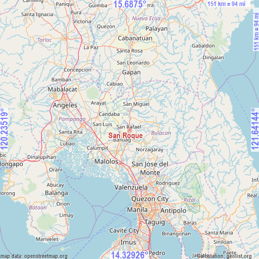
San Roque GPS coordinates[2]
15° 0' 34.056" North, 120° 56' 17.916" East
| Map corner | latitude | longitude |
|---|---|---|
| Upper-left | 15.6875°, | 120.23519° |
| Center: | 15.00946°, | 120.93831° |
| Lower-right: | 14.32926°, | 121.64144° |
| Map W x H: | 151×151 km | = 93.8×93.8mi |
| max Lat: | 20.78733° ⇑22.4% North |
| San Roque: | 15.00946° |
| min Lat: | ⇓77.6% South 4.65442° |
| min Long | San Roque | max Long |
| 117.04868° | 120.93831° | 126.58417° |
| W 21.8%⇐ | ⇒78.2% E |
Elevation
Elevation of San Roque is 38 m = 125 ft, and this is 49.9 m = 164 ft below average elevation for this country.
| Max E: |
2262 m = 7421 ft | 37.1% |
| Avg. | 87.9 m = 288 ft | |
| San Roque | 38 m = 125 ft | |
Min E: |
-2 m = -7 ft | 62.9% |
See also: Philippines elevation on elevation.city.
Geographical zone
San Roque is located in North Torrid zone (between Equator and Tropic of Cancer). Distance of this Northern Tropic circle is 937 km =582.2 mi to North.| Distance of | km | miles | from San Roque |
|---|---|---|---|
| North Pole | 8338.2 | 5181.1 | to North |
| Arctic Circle | 5732.3 | 3561.9 | to North |
| Tropic Cancer | 937 | 582.2 | to North |
| Equator | 1668.9 | 1037 | to South |


Nearby cities:
15 places around San Roque: (largest is in red/bold)
• Bahay Pare
6.7 km =4.2 mi,  292°
292°
• Baliuag
7.5 km =4.7 mi,  216°
216°
• Bustos
6.1 km =3.8 mi,  201°
201°
• Diliman Primero
2.2 km =1.4 mi,  41°
41°
• Lourdes
9.4 km =5.8 mi,  276°
276°
• Maasim
10.1 km =6.3 mi,  98°
98°
• Maguinao
1.5 km =0.9 mi,  342°
342°
• Niugan
7.7 km =4.8 mi,  156°
156°
• Pantubig
4.9 km =3 mi, 159°
• Pulo
9.7 km =6 mi,  122°
122°
• San Ildefonso
7.9 km =4.9 mi,  2°
2°
• San Rafael
7.3 km =4.5 mi, 159°
• Upig
6 km =3.7 mi,  72°
72°
• Vizal San Pablo
7.2 km =4.5 mi,  325°
325°
• Vizal Santo Niño
4.2 km =2.6 mi,  301°
301°
Sources, notices
• [Note1] Compared only with cities in Philippines existing in our database
• [Src1] Map data: © OpenStreetMap contributors (CC-BY-SA)
• [Src2] Other city data from geonames.org with taken over terms of usage.
• [Src3] Geographical zone / Annual Mean Temperature by Robert A. Rohde @ Wikipedia
