Tuli geodata
Tuli (Davao) is a populated place; located in Philippines in Asia/Manila (GMT+8) time zone. With population of 3,643 people, there are 1954 cities with bigger population in this country. Compared to other cities in Philippines, 89.1% of cities are located further ↑North; 92.3% of cities are located further ←West and 91.4% of cities have lower elevation than Tuli. Note1


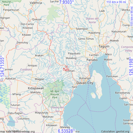
Tuli GPS coordinates[2]
7° 13' 59.988" North, 125° 25' 0.012" East
| Map corner | latitude | longitude |
|---|---|---|
| Upper-left | 7.9303°, | 124.71355° |
| Center: | 7.23333°, | 125.41667° |
| Lower-right: | 6.53528°, | 126.1198° |
| Map W x H: | 155.1×155.1 km | = 96.4×96.4mi |
| max Lat: | 20.78733° ⇑89.1% North |
| Tuli: | 7.23333° |
| min Lat: | ⇓10.9% South 4.65442° |
| min Long | Tuli | max Long |
| 117.04868° | 125.41667° | 126.58417° |
| W 92.3%⇐ | ⇒7.7% E |
Elevation
Elevation of Tuli is 271 m = 889 ft, and this is 183.1 m = 601 ft above average elevation for this country.
| Max E: |
2262 m = 7421 ft | 8.6% |
| Tuli | 271 m 889 ft | |
| Avg. | 87.9 m = 288 ft | |
Min E: |
-2 m = -7 ft | 91.4% |
See also: Philippines elevation on elevation.city.
Geographical zone
Tuli is located in North Torrid zone (between Equator and Tropic of Cancer). Distance of Equator is 804.3 km =499.8 mi to South.| Distance of | km | miles | from Tuli |
|---|---|---|---|
| North Pole | 9202.8 | 5718.4 | to North |
| Arctic Circle | 6596.9 | 4099.1 | to North |
| Tropic Cancer | 1801.6 | 1119.5 | to North |
| Equator | 804.3 | 499.8 | to South |


Nearby cities:
15 places around Tuli: (largest is in red/bold)
• Biao
13.9 km =8.6 mi,  124°
124°
• Dacudao
6.4 km =4 mi,  108°
108°
• Gumalang
3.1 km =1.9 mi,  207°
207°
• Lacson
3.7 km =2.3 mi,  130°
130°
• Mabuhay
18.2 km =11.3 mi,  52°
52°
• Malagos
5.4 km =3.4 mi,  173°
173°
• Manay
21.2 km =13.2 mi,  55°
55°
• Sirib
11.2 km =7 mi,  185°
185°
• Tagakpan
13.5 km =8.4 mi, 174°
• Tamayong
11.9 km =7.4 mi,  200°
200°
• Tamugan
4.5 km =2.8 mi,  266°
266°
• Tawan tawan
8.6 km =5.3 mi, 214°
• Ula
14 km =8.7 mi,  143°
143°
• Wañgan
8.8 km =5.5 mi,  158°
158°
• Wines
5.3 km =3.3 mi, 214°
Sources, notices
• [Note1] Compared only with cities in Philippines existing in our database
• [Src1] Map data: © OpenStreetMap contributors (CC-BY-SA)
• [Src2] Other city data from geonames.org with taken over terms of usage.
• [Src3] Geographical zone / Annual Mean Temperature by Robert A. Rohde @ Wikipedia
