Tamugan geodata
Tamugan (Davao) is a populated place; located in Philippines in Asia/Manila (GMT+8) time zone. With population of 8,291 people, there are 746 cities with bigger population in this country. Compared to other cities in Philippines, 89.1% of cities are located further ↑North; 91.9% of cities are located further ←West and 93.8% of cities have lower elevation than Tamugan. Note1


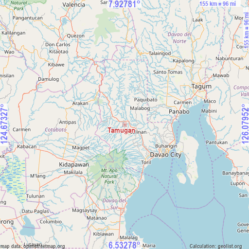
Tamugan GPS coordinates[2]
7° 13' 50.988" North, 125° 22' 35.004" East
| Map corner | latitude | longitude |
|---|---|---|
| Upper-left | 7.92781°, | 124.67327° |
| Center: | 7.23083°, | 125.37639° |
| Lower-right: | 6.53278°, | 126.07952° |
| Map W x H: | 155.1×155.1 km | = 96.4×96.4mi |
| max Lat: | 20.78733° ⇑89.1% North |
| Tamugan: | 7.23083° |
| min Lat: | ⇓10.9% South 4.65442° |
| min Long | Tamugan | max Long |
| 117.04868° | 125.37639° | 126.58417° |
| W 91.9%⇐ | ⇒8.1% E |
Elevation
Elevation of Tamugan is 364 m = 1194 ft, and this is 276.1 m = 906 ft above average elevation for this country.
| Max E: |
2262 m = 7421 ft | 6.2% |
| Tamugan | 364 m 1194 ft | |
| Avg. | 87.9 m = 288 ft | |
Min E: |
-2 m = -7 ft | 93.8% |
See also: Philippines elevation on elevation.city.
Geographical zone
Tamugan is located in North Torrid zone (between Equator and Tropic of Cancer). Distance of Equator is 804 km =499.6 mi to South.| Distance of | km | miles | from Tamugan |
|---|---|---|---|
| North Pole | 9203.1 | 5718.5 | to North |
| Arctic Circle | 6597.2 | 4099.3 | to North |
| Tropic Cancer | 1801.9 | 1119.6 | to North |
| Equator | 804 | 499.6 | to South |


Nearby cities:
15 places around Tamugan: (largest is in red/bold)
• Bato
23.4 km =14.5 mi,  152°
152°
• Biao
17.6 km =10.9 mi,  115°
115°
• Dacudao
10.6 km =6.6 mi,  99°
99°
• Gumalang
3.9 km =2.4 mi,  129°
129°
• Lacson
7.6 km =4.7 mi,  106°
106°
• Mabuhay
22 km =13.7 mi,  58°
58°
• Malagos
7.2 km =4.5 mi,  135°
135°
• Sirib
11.4 km =7.1 mi,  162°
162°
• Tagakpan
14.4 km =8.9 mi, 156°
• Tamayong
10.9 km =6.8 mi,  178°
178°
• Tawan tawan
6.9 km =4.3 mi, 183°
• Tuli
4.5 km =2.8 mi,  86°
86°
• Ula
16.8 km =10.4 mi, 130°
• Wañgan
11 km =6.8 mi, 136°
• Wines
4.3 km =2.7 mi, 161°
Sources, notices
• [Note1] Compared only with cities in Philippines existing in our database
• [Src1] Map data: © OpenStreetMap contributors (CC-BY-SA)
• [Src2] Other city data from geonames.org with taken over terms of usage.
• [Src3] Geographical zone / Annual Mean Temperature by Robert A. Rohde @ Wikipedia
