Iligan City geodata
Iligan City (Soccsksargen) is a populated place; located in Philippines in Asia/Manila (GMT+8) time zone. With population of 312,323 people, there are 26 cities with bigger population in this country. Compared to other cities in Philippines, 80.4% of cities are located further ↑North; 77.3% of cities are located further ←West and 91.9% of cities have lower elevation than Iligan City. Note1


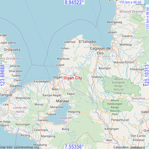
Iligan City GPS coordinates[2]
8° 15' 0" North, 124° 24' 0" East
| Map corner | latitude | longitude |
|---|---|---|
| Upper-left | 8.94522°, | 123.69688° |
| Center: | 8.25°, | 124.4° |
| Lower-right: | 7.55356°, | 125.10313° |
| Map W x H: | 154.7×154.7 km | = 96.1×96.1mi |
| max Lat: | 20.78733° ⇑80.4% North |
| Iligan City: | 8.25° |
| min Lat: | ⇓19.6% South 4.65442° |
| min Long | Iligan City | max Long |
| 117.04868° | 124.4° | 126.58417° |
| W 77.3%⇐ | ⇒22.7% E |
Elevation
Elevation of Iligan City is 282 m = 925 ft, and this is 194.1 m = 637 ft above average elevation for this country.
| Max E: |
2262 m = 7421 ft | 8.1% |
| Iligan City | 282 m 925 ft | |
| Avg. | 87.9 m = 288 ft | |
Min E: |
-2 m = -7 ft | 91.9% |
See also: Iligan City elevation on elevation.city.
Geographical zone
Iligan City is located in North Torrid zone (between Equator and Tropic of Cancer). Distance of Equator is 917.3 km =570 mi to South.| Distance of | km | miles | from Iligan City |
|---|---|---|---|
| North Pole | 9089.7 | 5648.1 | to North |
| Arctic Circle | 6483.9 | 4028.9 | to North |
| Tropic Cancer | 1688.6 | 1049.2 | to North |
| Equator | 917.3 | 570 | to South |


Nearby cities:
15 places around Iligan City: (largest is in red/bold)
• Biga
19.5 km =12.1 mi,  307°
307°
• Buawan
13 km =8.1 mi,  304°
304°
• Dalipuga
17.6 km =10.9 mi,  294°
294°
• Digkilaan
9.1 km =5.7 mi,  270°
270°
• Iligan
17.4 km =10.8 mi,  262°
262°
• Kabalantian
15.6 km =9.7 mi,  329°
329°
• Libertad
18.3 km =11.4 mi, 270°
• Lugait
18.5 km =11.5 mi, 303°
• Manticao
21.2 km =13.2 mi,  323°
323°
• Mat-i
17.9 km =11.1 mi,  340°
340°
• Punta Silum
20.5 km =12.7 mi, 315°
• Rogongon
7.6 km =4.7 mi, 255°
• San Isidro
21.3 km =13.2 mi,  87°
87°
• Tignapalan
19.3 km =12 mi, 85°
• Tuod
11.5 km =7.1 mi, 334°
Sources, notices
• [Note1] Compared only with cities in Philippines existing in our database
• [Src1] Map data: © OpenStreetMap contributors (CC-BY-SA)
• [Src2] Other city data from geonames.org with taken over terms of usage.
• [Src3] Geographical zone / Annual Mean Temperature by Robert A. Rohde @ Wikipedia
