Rogongon geodata
Rogongon (Soccsksargen) is a populated place; located in Philippines in Asia/Manila (GMT+8) time zone. With population of 5,530 people, there are 1148 cities with bigger population in this country. Compared to other cities in Philippines, 80.5% of cities are located further ↑North; 76.3% of cities are located further ←West and 90.3% of cities have lower elevation than Rogongon. Note1


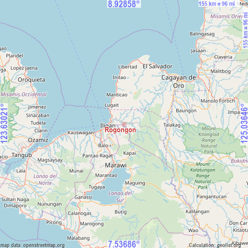
Rogongon GPS coordinates[2]
8° 13' 59.988" North, 124° 19' 59.988" East
| Map corner | latitude | longitude |
|---|---|---|
| Upper-left | 8.92858°, | 123.63021° |
| Center: | 8.23333°, | 124.33333° |
| Lower-right: | 7.53686°, | 125.03646° |
| Map W x H: | 154.7×154.7 km | = 96.1×96.1mi |
| max Lat: | 20.78733° ⇑80.5% North |
| Rogongon: | 8.23333° |
| min Lat: | ⇓19.5% South 4.65442° |
| min Long | Rogongon | max Long |
| 117.04868° | 124.33333° | 126.58417° |
| W 76.3%⇐ | ⇒23.7% E |
Elevation
Elevation of Rogongon is 235 m = 771 ft, and this is 147.1 m = 483 ft above average elevation for this country.
| Max E: |
2262 m = 7421 ft | 9.7% |
| Rogongon | 235 m 771 ft | |
| Avg. | 87.9 m = 288 ft | |
Min E: |
-2 m = -7 ft | 90.3% |
See also: Philippines elevation on elevation.city.
Geographical zone
Rogongon is located in North Torrid zone (between Equator and Tropic of Cancer). Distance of Equator is 915.5 km =568.9 mi to South.| Distance of | km | miles | from Rogongon |
|---|---|---|---|
| North Pole | 9091.6 | 5649.3 | to North |
| Arctic Circle | 6485.7 | 4030 | to North |
| Tropic Cancer | 1690.5 | 1050.4 | to North |
| Equator | 915.5 | 568.9 | to South |


Nearby cities:
15 places around Rogongon: (largest is in red/bold)
• Biga
16 km =9.9 mi,  329°
329°
• Buawan
9.8 km =6.1 mi,  340°
340°
• Dalipuga
12.6 km =7.8 mi,  316°
316°
• Digkilaan
2.7 km =1.7 mi, 318°
• Iligan
9.9 km =6.2 mi,  267°
267°
• Iligan City
7.6 km =4.7 mi,  75°
75°
• Kabalantian
15.3 km =9.5 mi,  357°
357°
• Libertad
11.2 km =7 mi,  279°
279°
• Lugait
14.5 km =9 mi, 325°
• Mamungan
18.1 km =11.2 mi,  224°
224°
• Mantampay
14.8 km =9.2 mi,  240°
240°
• Maria Cristina
16.1 km =10 mi, 242°
• Nañgka
18.1 km =11.2 mi,  245°
245°
• Punta Silum
17.9 km =11.1 mi, 336°
• Tuod
12.4 km =7.7 mi,  10°
10°
Sources, notices
• [Note1] Compared only with cities in Philippines existing in our database
• [Src1] Map data: © OpenStreetMap contributors (CC-BY-SA)
• [Src2] Other city data from geonames.org with taken over terms of usage.
• [Src3] Geographical zone / Annual Mean Temperature by Robert A. Rohde @ Wikipedia
