Tungao geodata
Tungao (Caraga) is a populated place; located in Philippines in Asia/Manila (GMT+8) time zone. With population of 8,910 people, there are 694 cities with bigger population in this country. Compared to other cities in Philippines, 77% of cities are located further ↑North; 94.5% of cities are located further ←West and 51.1% of cities have lower elevation than Tungao. Note1
Administrative division(s):
- Level 1: Caraga
- Level 2: Province of Agusan del Norte
- Level 3: Butuan City


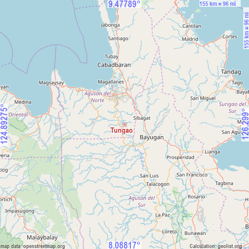
Tungao GPS coordinates[2]
8° 47' 1.248" North, 125° 35' 45.132" East
| Map corner | latitude | longitude |
|---|---|---|
| Upper-left | 9.47789°, | 124.89275° |
| Center: | 8.78368°, | 125.59587° |
| Lower-right: | 8.08817°, | 126.299° |
| Map W x H: | 154.5×154.5 km | = 96×96mi |
| max Lat: | 20.78733° ⇑77% North |
| Tungao: | 8.78368° |
| min Lat: | ⇓23% South 4.65442° |
| min Long | Tungao | max Long |
| 117.04868° | 125.59587° | 126.58417° |
| W 94.5%⇐ | ⇒5.5% E |
Elevation
Elevation of Tungao is 24 m = 79 ft, and this is 63.9 m = 210 ft below average elevation for this country.
| Max E: |
2262 m = 7421 ft | 48.9% |
| Avg. | 87.9 m = 288 ft | |
| Tungao | 24 m = 79 ft | |
Min E: |
-2 m = -7 ft | 51.1% |
See also: Philippines elevation on elevation.city.
Geographical zone
Tungao is located in North Torrid zone (between Equator and Tropic of Cancer). Distance of Equator is 976.7 km =606.9 mi to South.| Distance of | km | miles | from Tungao |
|---|---|---|---|
| North Pole | 9030.4 | 5611.2 | to North |
| Arctic Circle | 6424.5 | 3992 | to North |
| Tropic Cancer | 1629.3 | 1012.4 | to North |
| Equator | 976.7 | 606.9 | to South |


Nearby cities:
15 places around Tungao: (largest is in red/bold)
• Anticala
25.1 km =15.6 mi,  12°
12°
• Bancasi
24.8 km =15.4 mi,  325°
325°
• Basag
16 km =9.9 mi, 10°
• Bayugan
19.1 km =11.9 mi,  99°
99°
• Butuan
19.3 km =12 mi,  342°
342°
• Esperanza
13.1 km =8.1 mi,  154°
154°
• Guadalupe
25.5 km =15.8 mi, 151°
• Guinabsan
23.5 km =14.6 mi,  302°
302°
• Libertad
20.6 km =12.8 mi, 329°
• Lombocan
26.8 km =16.7 mi, 338°
• Los Angeles
25.5 km =15.8 mi,  3°
3°
• Maygatasan
15.8 km =9.8 mi,  121°
121°
• Salvacion
16.4 km =10.2 mi,  136°
136°
• Sibagat
12 km =7.5 mi,  68°
68°
• Taligaman
15 km =9.3 mi,  26°
26°
Sources, notices
• [Note1] Compared only with cities in Philippines existing in our database
• [Src1] Map data: © OpenStreetMap contributors (CC-BY-SA)
• [Src2] Other city data from geonames.org with taken over terms of usage.
• [Src3] Geographical zone / Annual Mean Temperature by Robert A. Rohde @ Wikipedia
