Sibagat geodata
Sibagat (Caraga) is a populated place; located in Philippines in Asia/Manila (GMT+8) time zone. With population of 4,865 people, there are 1353 cities with bigger population in this country. Compared to other cities in Philippines, 76.9% of cities are located further ↑North; 95.6% of cities are located further ←West and 67.1% of cities have lower elevation than Sibagat. Note1


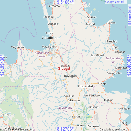
Sibagat GPS coordinates[2]
8° 49' 21" North, 125° 41' 51" East
| Map corner | latitude | longitude |
|---|---|---|
| Upper-left | 9.51664°, | 124.99438° |
| Center: | 8.8225°, | 125.6975° |
| Lower-right: | 8.12706°, | 126.40063° |
| Map W x H: | 154.5×154.5 km | = 96×96mi |
| max Lat: | 20.78733° ⇑76.9% North |
| Sibagat: | 8.8225° |
| min Lat: | ⇓23.1% South 4.65442° |
| min Long | Sibagat | max Long |
| 117.04868° | 125.6975° | 126.58417° |
| W 95.6%⇐ | ⇒4.4% E |
Elevation
Elevation of Sibagat is 46 m = 151 ft, and this is 41.9 m = 137 ft below average elevation for this country.
| Max E: |
2262 m = 7421 ft | 32.9% |
| Avg. | 87.9 m = 288 ft | |
| Sibagat | 46 m = 151 ft | |
Min E: |
-2 m = -7 ft | 67.1% |
See also: Philippines elevation on elevation.city.
Geographical zone
Sibagat is located in North Torrid zone (between Equator and Tropic of Cancer). Distance of Equator is 981 km =609.6 mi to South.| Distance of | km | miles | from Sibagat |
|---|---|---|---|
| North Pole | 9026.1 | 5608.6 | to North |
| Arctic Circle | 6420.2 | 3989.3 | to North |
| Tropic Cancer | 1624.9 | 1009.7 | to North |
| Equator | 981 | 609.6 | to South |


Nearby cities:
15 places around Sibagat: (largest is in red/bold)
• Agay
28.4 km =17.6 mi,  334°
334°
• Anticala
21 km =13 mi,  344°
344°
• Balangbalang
27.3 km =17 mi, 342°
• Basag
14.2 km =8.8 mi,  323°
323°
• Bayugan
10.7 km =6.6 mi,  133°
133°
• Butuan
22 km =13.7 mi,  309°
309°
• Esperanza
17.1 km =10.6 mi,  198°
198°
• Guadalupe
26.7 km =16.6 mi,  177°
177°
• Libertad
25.4 km =15.8 mi,  302°
302°
• Lombocan
29.5 km =18.3 mi, 314°
• Los Angeles
23.3 km =14.5 mi, 335°
• Maygatasan
12.8 km =8 mi,  169°
169°
• Salvacion
16.1 km =10 mi, 179°
• Taligaman
10.2 km =6.3 mi, 333°
• Tungao
12 km =7.5 mi,  248°
248°
Sources, notices
• [Note1] Compared only with cities in Philippines existing in our database
• [Src1] Map data: © OpenStreetMap contributors (CC-BY-SA)
• [Src2] Other city data from geonames.org with taken over terms of usage.
• [Src3] Geographical zone / Annual Mean Temperature by Robert A. Rohde @ Wikipedia
