Esperanza geodata
Esperanza (Caraga) is a populated place; located in Philippines in Asia/Manila (GMT+8) time zone. With population of 6,193 people, there are 1006 cities with bigger population in this country. Compared to other cities in Philippines, 77.3% of cities are located further ↑North; 95.1% of cities are located further ←West and 65.1% of cities have higher elevation than Esperanza. Note1


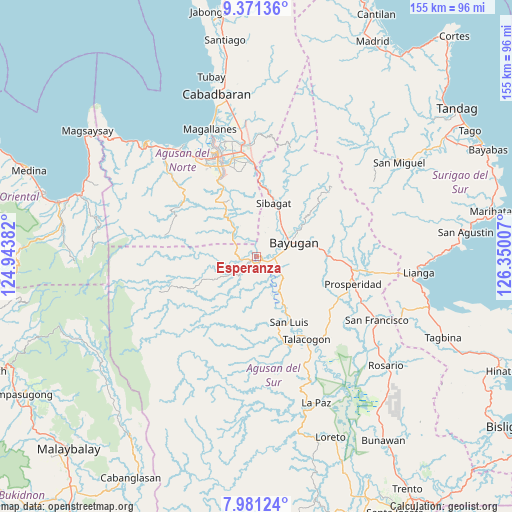
Esperanza GPS coordinates[2]
8° 40' 36.984" North, 125° 38' 48.984" East
| Map corner | latitude | longitude |
|---|---|---|
| Upper-left | 9.37136°, | 124.94382° |
| Center: | 8.67694°, | 125.64694° |
| Lower-right: | 7.98124°, | 126.35007° |
| Map W x H: | 154.6×154.6 km | = 96.1×96.1mi |
| max Lat: | 20.78733° ⇑77.3% North |
| Esperanza: | 8.67694° |
| min Lat: | ⇓22.7% South 4.65442° |
| min Long | Esperanza | max Long |
| 117.04868° | 125.64694° | 126.58417° |
| W 95.1%⇐ | ⇒4.9% E |
Elevation
Elevation of Esperanza is 14 m = 46 ft, and this is 73.9 m = 242 ft below average elevation for this country.
| Max E: |
2262 m = 7421 ft | 65.1% |
| Avg. | 87.9 m = 288 ft | |
| Esperanza | 14 m = 46 ft | |
Min E: |
-2 m = -7 ft | 34.9% |
See also: Philippines elevation on elevation.city.
Geographical zone
Esperanza is located in North Torrid zone (between Equator and Tropic of Cancer). Distance of Equator is 964.8 km =599.5 mi to South.| Distance of | km | miles | from Esperanza |
|---|---|---|---|
| North Pole | 9042.3 | 5618.6 | to North |
| Arctic Circle | 6436.4 | 3999.4 | to North |
| Tropic Cancer | 1641.1 | 1019.7 | to North |
| Equator | 964.8 | 599.5 | to South |


Nearby cities:
15 places around Esperanza: (largest is in red/bold)
• Aurora
22.9 km =14.2 mi,  113°
113°
• Bah-Bah
30.4 km =18.9 mi,  104°
104°
• Basag
27.8 km =17.3 mi,  354°
354°
• Bayugan
15.9 km =9.9 mi,  56°
56°
• Butuan
32.3 km =20.1 mi,  339°
339°
• Guadalupe
12.4 km =7.7 mi,  147°
147°
• Kauswagan
21.1 km =13.1 mi, 147°
• Maygatasan
8.6 km =5.3 mi,  65°
65°
• Prosperidad
29.5 km =18.3 mi, 111°
• Salvacion
5.7 km =3.5 mi,  89°
89°
• San Luis
24.5 km =15.2 mi, 154°
• Sibagat
17.1 km =10.6 mi,  18°
18°
• Talacogon
28.8 km =17.9 mi, 148°
• Taligaman
25.3 km =15.7 mi,  2°
2°
• Tungao
13.1 km =8.1 mi,  334°
334°
Sources, notices
• [Note1] Compared only with cities in Philippines existing in our database
• [Src1] Map data: © OpenStreetMap contributors (CC-BY-SA)
• [Src2] Other city data from geonames.org with taken over terms of usage.
• [Src3] Geographical zone / Annual Mean Temperature by Robert A. Rohde @ Wikipedia
