Guadalupe geodata
Guadalupe (Caraga) is a populated place; located in Philippines in Asia/Manila (GMT+8) time zone. With population of 3,381 people, there are 2154 cities with bigger population in this country. Compared to other cities in Philippines, 77.8% of cities are located further ↑North; 95.8% of cities are located further ←West and 52.3% of cities have lower elevation than Guadalupe. Note1


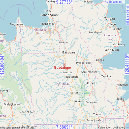
Guadalupe GPS coordinates[2]
8° 34' 58.008" North, 125° 42' 29.016" East
| Map corner | latitude | longitude |
|---|---|---|
| Upper-left | 9.27738°, | 125.00494° |
| Center: | 8.58278°, | 125.70806° |
| Lower-right: | 7.88691°, | 126.41119° |
| Map W x H: | 154.6×154.6 km | = 96.1×96.1mi |
| max Lat: | 20.78733° ⇑77.8% North |
| Guadalupe: | 8.58278° |
| min Lat: | ⇓22.2% South 4.65442° |
| min Long | Guadalupe | max Long |
| 117.04868° | 125.70806° | 126.58417° |
| W 95.8%⇐ | ⇒4.2% E |
Elevation
Elevation of Guadalupe is 25 m = 82 ft, and this is 62.9 m = 206 ft below average elevation for this country.
| Max E: |
2262 m = 7421 ft | 47.7% |
| Avg. | 87.9 m = 288 ft | |
| Guadalupe | 25 m = 82 ft | |
Min E: |
-2 m = -7 ft | 52.3% |
See also: Philippines elevation on elevation.city.
Geographical zone
Guadalupe is located in North Torrid zone (between Equator and Tropic of Cancer). Distance of Equator is 954.3 km =593 mi to South.| Distance of | km | miles | from Guadalupe |
|---|---|---|---|
| North Pole | 9052.7 | 5625.1 | to North |
| Arctic Circle | 6446.9 | 4005.9 | to North |
| Tropic Cancer | 1651.6 | 1026.3 | to North |
| Equator | 954.3 | 593 | to South |


Nearby cities:
15 places around Guadalupe: (largest is in red/bold)
• Aurora
14.3 km =8.9 mi,  85°
85°
• Bah-Bah
22.9 km =14.2 mi,  83°
83°
• Bayugan
20.3 km =12.6 mi,  18°
18°
• Borbon
23.1 km =14.4 mi,  118°
118°
• Causwagan
20.9 km =13 mi,  135°
135°
• Esperanza
12.4 km =7.7 mi,  327°
327°
• Kauswagan
8.7 km =5.4 mi,  147°
147°
• Maygatasan
14.1 km =8.8 mi,  4°
4°
• Patin-ay
25.4 km =15.8 mi,  98°
98°
• Prosperidad
20.7 km =12.9 mi, 90°
• Salvacion
10.6 km =6.6 mi,  354°
354°
• San Luis
12.3 km =7.6 mi,  161°
161°
• Sibagat
26.7 km =16.6 mi,  357°
357°
• Talacogon
16.4 km =10.2 mi, 149°
• Tungao
25.5 km =15.8 mi, 331°
Sources, notices
• [Note1] Compared only with cities in Philippines existing in our database
• [Src1] Map data: © OpenStreetMap contributors (CC-BY-SA)
• [Src2] Other city data from geonames.org with taken over terms of usage.
• [Src3] Geographical zone / Annual Mean Temperature by Robert A. Rohde @ Wikipedia
