Maygatasan geodata
Maygatasan (Caraga) is a populated place; located in Philippines in Asia/Manila (GMT+8) time zone. With population of 4,014 people, there are 1719 cities with bigger population in this country. Compared to other cities in Philippines, 77.3% of cities are located further ↑North; 95.9% of cities are located further ←West and 54.4% of cities have lower elevation than Maygatasan. Note1
Administrative division(s):
- Level 1: Caraga
- Level 2: Province of Agusan del Sur
- Level 3: City of Bayugan


Maygatasan GPS coordinates[2]
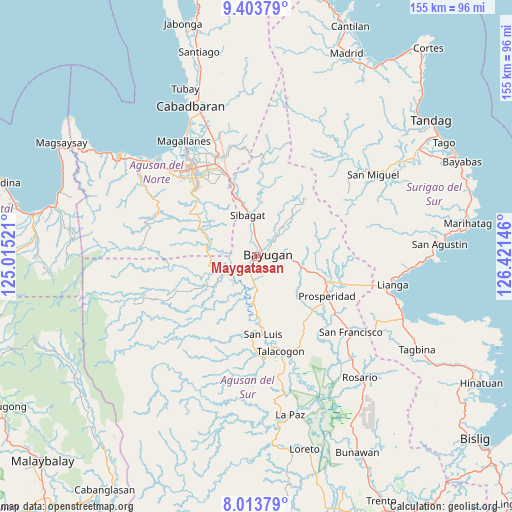
8° 42' 33.984" North, 125° 43' 5.988" East
| Map corner | latitude | longitude |
|---|---|---|
| Upper-left | 9.40379°, | 125.01521° |
| Center: | 8.70944°, | 125.71833° |
| Lower-right: | 8.01379°, | 126.42146° |
| Map W x H: | 154.6×154.6 km | = 96.1×96.1mi |
| max Lat: | 20.78733° ⇑77.3% North |
| Maygatasan: | 8.70944° |
| min Lat: | ⇓22.7% South 4.65442° |
| min Long | Maygatasan | max Long |
| 117.04868° | 125.71833° | 126.58417° |
| W 95.9%⇐ | ⇒4.1% E |
Elevation
Elevation of Maygatasan is 27 m = 89 ft, and this is 60.9 m = 200 ft below average elevation for this country.
| Max E: |
2262 m = 7421 ft | 45.6% |
| Avg. | 87.9 m = 288 ft | |
| Maygatasan | 27 m = 89 ft | |
Min E: |
-2 m = -7 ft | 54.4% |
See also: Philippines elevation on elevation.city.
Geographical zone
Maygatasan is located in North Torrid zone (between Equator and Tropic of Cancer). Distance of Equator is 968.4 km =601.7 mi to South.| Distance of | km | miles | from Maygatasan |
|---|---|---|---|
| North Pole | 9038.7 | 5616.4 | to North |
| Arctic Circle | 6432.8 | 3997.2 | to North |
| Tropic Cancer | 1637.5 | 1017.5 | to North |
| Equator | 968.4 | 601.7 | to South |


Nearby cities:
15 places around Maygatasan: (largest is in red/bold)
• Aurora
18.4 km =11.4 mi,  134°
134°
• Bah-Bah
24.4 km =15.2 mi,  117°
117°
• Basag
26.3 km =16.3 mi,  336°
336°
• Bayugan
7.5 km =4.7 mi,  46°
46°
• Esperanza
8.6 km =5.3 mi,  245°
245°
• Guadalupe
14.1 km =8.8 mi,  184°
184°
• Kauswagan
21.7 km =13.5 mi,  170°
170°
• Patin-ay
29.9 km =18.6 mi, 126°
• Prosperidad
24.3 km =15.1 mi, 126°
• Salvacion
4.1 km =2.5 mi,  210°
210°
• San Luis
25.9 km =16.1 mi, 173°
• Sibagat
12.8 km =8 mi,  349°
349°
• Talacogon
29.1 km =18.1 mi, 165°
• Taligaman
22.7 km =14.1 mi, 342°
• Tungao
15.8 km =9.8 mi,  301°
301°
Sources, notices
• [Note1] Compared only with cities in Philippines existing in our database
• [Src1] Map data: © OpenStreetMap contributors (CC-BY-SA)
• [Src2] Other city data from geonames.org with taken over terms of usage.
• [Src3] Geographical zone / Annual Mean Temperature by Robert A. Rohde @ Wikipedia
