Tondod geodata
Tondod (Central Luzon) is a populated place; located in Philippines in Asia/Manila (GMT+8) time zone. With population of 3,182 people, there are 2327 cities with bigger population in this country. Compared to other cities in Philippines, 84.1% of cities are located further ↓South; 77.1% of cities are located further →East and 79.1% of cities have lower elevation than Tondod. Note1
Administrative division(s):
- Level 1: Central Luzon
- Level 2: Province of Nueva Ecija
- Level 3: San Jose City


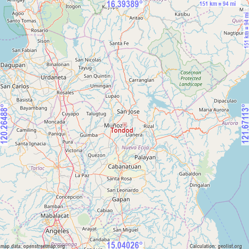
Tondod GPS coordinates[2]
15° 43' 5.52" North, 120° 58' 4.8" East
| Map corner | latitude | longitude |
|---|---|---|
| Upper-left | 16.39389°, | 120.26488° |
| Center: | 15.7182°, | 120.968° |
| Lower-right: | 15.04026°, | 121.67113° |
| Map W x H: | 150.5×150.5 km | = 93.5×93.5mi |
| max Lat: | 20.78733° ⇑15.9% North |
| Tondod: | 15.7182° |
| min Lat: | ⇓84.1% South 4.65442° |
| min Long | Tondod | max Long |
| 117.04868° | 120.968° | 126.58417° |
| W 22.9%⇐ | ⇒77.1% E |
Elevation
Elevation of Tondod is 86 m = 282 ft, and this is 1.9 m = 6 ft below average elevation for this country.
| Max E: |
2262 m = 7421 ft | 20.9% |
| Avg. | 87.9 m = 288 ft | |
| Tondod | 86 m = 282 ft | |
Min E: |
-2 m = -7 ft | 79.1% |
See also: Philippines elevation on elevation.city.
Geographical zone
Tondod is located in North Torrid zone (between Equator and Tropic of Cancer). Distance of this Northern Tropic circle is 858.2 km =533.3 mi to North.| Distance of | km | miles | from Tondod |
|---|---|---|---|
| North Pole | 8259.4 | 5132.2 | to North |
| Arctic Circle | 5653.5 | 3512.9 | to North |
| Tropic Cancer | 858.2 | 533.3 | to North |
| Equator | 1747.7 | 1086 | to South |


Nearby cities:
15 places around Tondod: (largest is in red/bold)
• Baloc
12.1 km =7.5 mi,  226°
226°
• Bicos
10.2 km =6.3 mi,  129°
129°
• Del Pilar
12.9 km =8 mi,  101°
101°
• Estrella
7.8 km =4.8 mi,  63°
63°
• Llanera
8.1 km =5 mi,  138°
138°
• Magtangol
7.1 km =4.4 mi,  308°
308°
• Maligaya
9.8 km =6.1 mi,  240°
240°
• Muñoz
7 km =4.3 mi,  268°
268°
• Palusapis
11.9 km =7.4 mi,  250°
250°
• Plaridel
8.7 km =5.4 mi, 139°
• Porais
9 km =5.6 mi, 62°
• Santo Tomas
3.6 km =2.2 mi,  350°
350°
• Sibul
9.7 km =6 mi,  20°
20°
• Tabacao
8.2 km =5.1 mi,  201°
201°
• Villa Isla
12.3 km =7.6 mi,  298°
298°
Sources, notices
• [Note1] Compared only with cities in Philippines existing in our database
• [Src1] Map data: © OpenStreetMap contributors (CC-BY-SA)
• [Src2] Other city data from geonames.org with taken over terms of usage.
• [Src3] Geographical zone / Annual Mean Temperature by Robert A. Rohde @ Wikipedia
