Llanera geodata
Llanera (Central Luzon) is a seat of a third-order administrative division; located in Philippines in Asia/Manila (GMT+8) time zone. With population of 5,121 people, there are 1251 cities with bigger population in this country. Compared to other cities in Philippines, 83.5% of cities are located further ↓South; 75.9% of cities are located further →East and 75.5% of cities have lower elevation than Llanera. Note1
Administrative division(s):
- Level 1: Central Luzon
- Level 2: Province of Nueva Ecija
- Level 3: Llanera


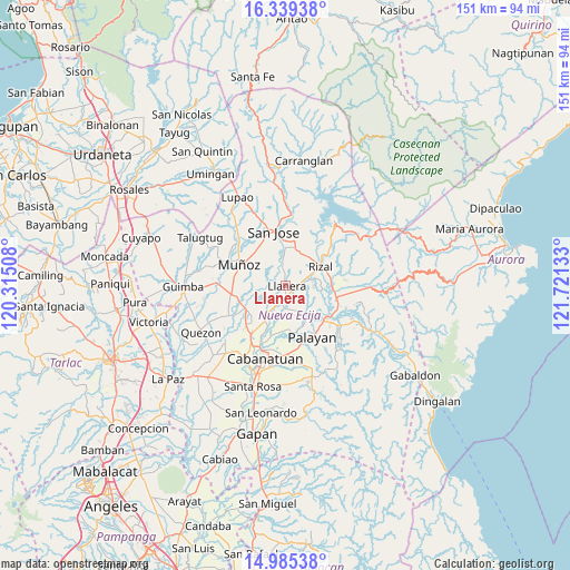
Llanera GPS coordinates[2]
15° 39' 48.6" North, 121° 1' 5.52" East
| Map corner | latitude | longitude |
|---|---|---|
| Upper-left | 16.33938°, | 120.31508° |
| Center: | 15.6635°, | 121.0182° |
| Lower-right: | 14.98538°, | 121.72133° |
| Map W x H: | 150.6×150.6 km | = 93.6×93.6mi |
| max Lat: | 20.78733° ⇑16.5% North |
| Llanera: | 15.6635° |
| min Lat: | ⇓83.5% South 4.65442° |
| min Long | Llanera | max Long |
| 117.04868° | 121.0182° | 126.58417° |
| W 24.1%⇐ | ⇒75.9% E |
Elevation
Elevation of Llanera is 70 m = 230 ft, and this is 17.9 m = 59 ft below average elevation for this country.
| Max E: |
2262 m = 7421 ft | 24.5% |
| Avg. | 87.9 m = 288 ft | |
| Llanera | 70 m = 230 ft | |
Min E: |
-2 m = -7 ft | 75.5% |
See also: Philippines elevation on elevation.city.
Geographical zone
Llanera is located in North Torrid zone (between Equator and Tropic of Cancer). Distance of this Northern Tropic circle is 864.3 km =537.1 mi to North.| Distance of | km | miles | from Llanera |
|---|---|---|---|
| North Pole | 8265.4 | 5135.9 | to North |
| Arctic Circle | 5659.6 | 3516.7 | to North |
| Tropic Cancer | 864.3 | 537.1 | to North |
| Equator | 1741.6 | 1082.2 | to South |


Nearby cities:
15 places around Llanera: (largest is in red/bold)
• Agbannawag
7.2 km =4.5 mi,  75°
75°
• Bicos
2.5 km =1.6 mi,  98°
98°
• Del Pilar
8.1 km =5 mi,  63°
63°
• Estrella
9.8 km =6.1 mi,  9°
9°
• General Mamerto Natividad
7.7 km =4.8 mi,  152°
152°
• Mabini
8 km =5 mi,  207°
207°
• Paco Roman
7.5 km =4.7 mi,  93°
93°
• Piñahan
6.2 km =3.9 mi,  131°
131°
• Plaridel
0.6 km =0.4 mi,  159°
159°
• Porais
10.5 km =6.5 mi, 14°
• Rizal
10.8 km =6.7 mi, 60°
• San Ricardo
9 km =5.6 mi, 212°
• Santo Tomas
11.3 km =7 mi,  328°
328°
• Tabacao
8.4 km =5.2 mi,  259°
259°
• Tondod
8.1 km =5 mi,  318°
318°
Sources, notices
• [Note1] Compared only with cities in Philippines existing in our database
• [Src1] Map data: © OpenStreetMap contributors (CC-BY-SA)
• [Src2] Other city data from geonames.org with taken over terms of usage.
• [Src3] Geographical zone / Annual Mean Temperature by Robert A. Rohde @ Wikipedia
