Bicos geodata
Bicos (Central Luzon) is a populated place; located in Philippines in Asia/Manila (GMT+8) time zone. With population of 3,962 people, there are 1754 cities with bigger population in this country. Compared to other cities in Philippines, 83.4% of cities are located further ↓South; 75.3% of cities are located further →East and 77.2% of cities have lower elevation than Bicos. Note1


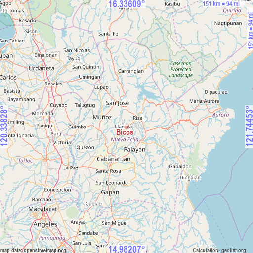
Bicos GPS coordinates[2]
15° 39' 36.72" North, 121° 2' 29.04" East
| Map corner | latitude | longitude |
|---|---|---|
| Upper-left | 16.33609°, | 120.33828° |
| Center: | 15.6602°, | 121.0414° |
| Lower-right: | 14.98207°, | 121.74453° |
| Map W x H: | 150.6×150.6 km | = 93.6×93.6mi |
| max Lat: | 20.78733° ⇑16.6% North |
| Bicos: | 15.6602° |
| min Lat: | ⇓83.4% South 4.65442° |
| min Long | Bicos | max Long |
| 117.04868° | 121.0414° | 126.58417° |
| W 24.7%⇐ | ⇒75.3% E |
Elevation
Elevation of Bicos is 76 m = 249 ft, and this is 11.9 m = 39 ft below average elevation for this country.
| Max E: |
2262 m = 7421 ft | 22.8% |
| Avg. | 87.9 m = 288 ft | |
| Bicos | 76 m = 249 ft | |
Min E: |
-2 m = -7 ft | 77.2% |
See also: Philippines elevation on elevation.city.
Geographical zone
Bicos is located in North Torrid zone (between Equator and Tropic of Cancer). Distance of this Northern Tropic circle is 864.7 km =537.3 mi to North.| Distance of | km | miles | from Bicos |
|---|---|---|---|
| North Pole | 8265.8 | 5136.1 | to North |
| Arctic Circle | 5659.9 | 3516.9 | to North |
| Tropic Cancer | 864.7 | 537.3 | to North |
| Equator | 1741.3 | 1082 | to South |


Nearby cities:
15 places around Bicos: (largest is in red/bold)
• Agbannawag
5 km =3.1 mi,  64°
64°
• Del Pilar
6.2 km =3.9 mi,  50°
50°
• Estrella
10 km =6.2 mi,  355°
355°
• General Mamerto Natividad
6.5 km =4 mi,  170°
170°
• Llanera
2.5 km =1.6 mi,  278°
278°
• Mabini
9.1 km =5.7 mi,  222°
222°
• Macapsing
9.9 km =6.2 mi,  78°
78°
• Paco Roman
5 km =3.1 mi,  90°
90°
• Piñahan
4.3 km =2.7 mi,  149°
149°
• Plaridel
2.3 km =1.4 mi,  265°
265°
• Porais
10.6 km =6.6 mi,  0°
0°
• Rizal
9 km =5.6 mi, 50°
• San Ricardo
10.3 km =6.4 mi,  225°
225°
• Tabacao
10.8 km =6.7 mi,  263°
263°
• Tondod
10.2 km =6.3 mi,  309°
309°
Sources, notices
• [Note1] Compared only with cities in Philippines existing in our database
• [Src1] Map data: © OpenStreetMap contributors (CC-BY-SA)
• [Src2] Other city data from geonames.org with taken over terms of usage.
• [Src3] Geographical zone / Annual Mean Temperature by Robert A. Rohde @ Wikipedia
