Estrella geodata
Estrella (Central Luzon) is a populated place; located in Philippines in Asia/Manila (GMT+8) time zone. With population of 4,463 people, there are 1514 cities with bigger population in this country. Compared to other cities in Philippines, 84.4% of cities are located further ↓South; 75.5% of cities are located further →East and 81.2% of cities have lower elevation than Estrella. Note1
Administrative division(s):
- Level 1: Central Luzon
- Level 2: Province of Nueva Ecija
- Level 3: San Jose City


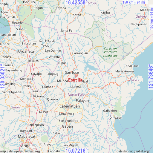
Estrella GPS coordinates[2]
15° 45' 0" North, 121° 1' 59.988" East
| Map corner | latitude | longitude |
|---|---|---|
| Upper-left | 16.42558°, | 120.33021° |
| Center: | 15.75°, | 121.03333° |
| Lower-right: | 15.07216°, | 121.73646° |
| Map W x H: | 150.5×150.5 km | = 93.5×93.5mi |
| max Lat: | 20.78733° ⇑15.6% North |
| Estrella: | 15.75° |
| min Lat: | ⇓84.4% South 4.65442° |
| min Long | Estrella | max Long |
| 117.04868° | 121.03333° | 126.58417° |
| W 24.5%⇐ | ⇒75.5% E |
Elevation
Elevation of Estrella is 101 m = 331 ft, and this is 13.1 m = 43 ft above average elevation for this country.
| Max E: |
2262 m = 7421 ft | 18.8% |
| Estrella | 101 m 331 ft | |
| Avg. | 87.9 m = 288 ft | |
Min E: |
-2 m = -7 ft | 81.2% |
See also: Philippines elevation on elevation.city.
Geographical zone
Estrella is located in North Torrid zone (between Equator and Tropic of Cancer). Distance of this Northern Tropic circle is 854.7 km =531.1 mi to North.| Distance of | km | miles | from Estrella |
|---|---|---|---|
| North Pole | 8255.8 | 5129.9 | to North |
| Arctic Circle | 5649.9 | 3510.7 | to North |
| Tropic Cancer | 854.7 | 531.1 | to North |
| Equator | 1751.2 | 1088.1 | to South |


Nearby cities:
15 places around Estrella: (largest is in red/bold)
• Agbannawag
9.5 km =5.9 mi,  145°
145°
• Bicos
10 km =6.2 mi,  175°
175°
• Del Pilar
8.3 km =5.2 mi,  136°
136°
• Llanera
9.8 km =6.1 mi,  189°
189°
• Macapsing
13.2 km =8.2 mi,  127°
127°
• Magtangol
12.6 km =7.8 mi,  274°
274°
• Paco Roman
11.6 km =7.2 mi, 149°
• Pantabangan
13.7 km =8.5 mi,  60°
60°
• Plaridel
10.3 km =6.4 mi, 187°
• Porais
1.2 km =0.7 mi, 60°
• Rizal
8.9 km =5.5 mi,  118°
118°
• Santo Tomas
7.6 km =4.7 mi, 269°
• Sibul
6.6 km =4.1 mi,  327°
327°
• Tayabo
9.4 km =5.8 mi,  358°
358°
• Tondod
7.8 km =4.8 mi,  243°
243°
Sources, notices
• [Note1] Compared only with cities in Philippines existing in our database
• [Src1] Map data: © OpenStreetMap contributors (CC-BY-SA)
• [Src2] Other city data from geonames.org with taken over terms of usage.
• [Src3] Geographical zone / Annual Mean Temperature by Robert A. Rohde @ Wikipedia
