Tiep geodata
Tiep (Ilocos) is a populated place; located in Philippines in Asia/Manila (GMT+8) time zone. With population of 2,178 people, there are 3928 cities with bigger population in this country. Compared to other cities in Philippines, 89.5% of cities are located further ↓South; 98.2% of cities are located further →East and 84.4% of cities have lower elevation than Tiep. Note1


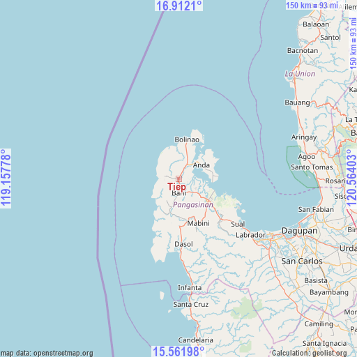
Tiep GPS coordinates[2]
16° 14' 17.52" North, 119° 51' 39.24" East
| Map corner | latitude | longitude |
|---|---|---|
| Upper-left | 16.9121°, | 119.15778° |
| Center: | 16.2382°, | 119.8609° |
| Lower-right: | 15.56198°, | 120.56403° |
| Map W x H: | 150.1×150.1 km | = 93.3×93.3mi |
| max Lat: | 20.78733° ⇑10.5% North |
| Tiep: | 16.2382° |
| min Lat: | ⇓89.5% South 4.65442° |
| min Long | Tiep | max Long |
| 117.04868° | 119.8609° | 126.58417° |
| W 1.8%⇐ | ⇒98.2% E |
Elevation
Elevation of Tiep is 127 m = 417 ft, and this is 39.1 m = 128 ft above average elevation for this country.
| Max E: |
2262 m = 7421 ft | 15.6% |
| Tiep | 127 m 417 ft | |
| Avg. | 87.9 m = 288 ft | |
Min E: |
-2 m = -7 ft | 84.4% |
See also: Philippines elevation on elevation.city.
Geographical zone
Tiep is located in North Torrid zone (between Equator and Tropic of Cancer). Distance of this Northern Tropic circle is 800.4 km =497.3 mi to North.| Distance of | km | miles | from Tiep |
|---|---|---|---|
| North Pole | 8201.5 | 5096.2 | to North |
| Arctic Circle | 5595.7 | 3477 | to North |
| Tropic Cancer | 800.4 | 497.3 | to North |
| Equator | 1805.5 | 1121.9 | to South |


Nearby cities:
15 places around Tiep: (largest is in red/bold)
• Agno
15.1 km =9.4 mi,  205°
205°
• Aloleng
14.6 km =9.1 mi,  215°
215°
• Anda
11.1 km =6.9 mi,  59°
59°
• Balingasay
13.3 km =8.3 mi,  357°
357°
• Bangan-Oda
14.8 km =9.2 mi,  192°
192°
• Bani
5.9 km =3.7 mi,  179°
179°
• Banog Sur
9 km =5.6 mi,  153°
153°
• Catuday
8.4 km =5.2 mi,  315°
315°
• Cayungnan
11.9 km =7.4 mi, 192°
• Macabuboni
10.1 km =6.3 mi,  238°
238°
• Pangapisan
10.6 km =6.6 mi,  103°
103°
• Polo
10.5 km =6.5 mi,  116°
116°
• Ranao
5.9 km =3.7 mi,  234°
234°
• Sablig
14 km =8.7 mi,  75°
75°
• Toritori
14.4 km =8.9 mi,  89°
89°
Sources, notices
• [Note1] Compared only with cities in Philippines existing in our database
• [Src1] Map data: © OpenStreetMap contributors (CC-BY-SA)
• [Src2] Other city data from geonames.org with taken over terms of usage.
• [Src3] Geographical zone / Annual Mean Temperature by Robert A. Rohde @ Wikipedia
