Toritori geodata
Toritori (Ilocos) is a populated place; located in Philippines in Asia/Manila (GMT+8) time zone. With population of 2,076 people, there are 4110 cities with bigger population in this country. Compared to other cities in Philippines, 89.5% of cities are located further ↓South; 97.1% of cities are located further →East and 51.1% of cities have lower elevation than Toritori. Note1


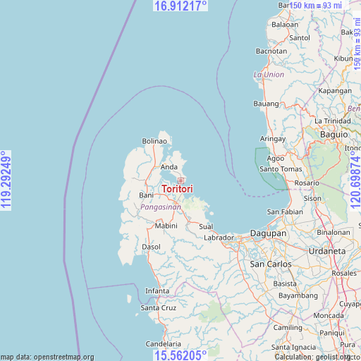
Toritori GPS coordinates[2]
16° 14' 17.772" North, 119° 59' 44.196" East
| Map corner | latitude | longitude |
|---|---|---|
| Upper-left | 16.91217°, | 119.29249° |
| Center: | 16.23827°, | 119.99561° |
| Lower-right: | 15.56205°, | 120.69874° |
| Map W x H: | 150.1×150.1 km | = 93.3×93.3mi |
| max Lat: | 20.78733° ⇑10.5% North |
| Toritori: | 16.23827° |
| min Lat: | ⇓89.5% South 4.65442° |
| min Long | Toritori | max Long |
| 117.04868° | 119.99561° | 126.58417° |
| W 2.9%⇐ | ⇒97.1% E |
Elevation
Elevation of Toritori is 24 m = 79 ft, and this is 63.9 m = 210 ft below average elevation for this country.
| Max E: |
2262 m = 7421 ft | 48.9% |
| Avg. | 87.9 m = 288 ft | |
| Toritori | 24 m = 79 ft | |
Min E: |
-2 m = -7 ft | 51.1% |
See also: Philippines elevation on elevation.city.
Geographical zone
Toritori is located in North Torrid zone (between Equator and Tropic of Cancer). Distance of this Northern Tropic circle is 800.4 km =497.3 mi to North.| Distance of | km | miles | from Toritori |
|---|---|---|---|
| North Pole | 8201.5 | 5096.2 | to North |
| Arctic Circle | 5595.6 | 3476.9 | to North |
| Tropic Cancer | 800.4 | 497.3 | to North |
| Equator | 1805.5 | 1121.9 | to South |


Nearby cities:
15 places around Toritori: (largest is in red/bold)
• Alaminos
9.3 km =5.8 mi,  189°
189°
• Anda
7.5 km =4.7 mi,  319°
319°
• Bani
15.5 km =9.6 mi,  247°
247°
• Banog Sur
13.2 km =8.2 mi,  232°
232°
• Bued
8.6 km =5.3 mi,  177°
177°
• Cabungan
11.3 km =7 mi,  359°
359°
• Carot
11.9 km =7.4 mi,  352°
352°
• Lucap
5.4 km =3.4 mi,  172°
172°
• Pangapisan
4.8 km =3 mi,  239°
239°
• Pangascasan
16.6 km =10.3 mi,  144°
144°
• Polo
6.8 km =4.2 mi, 226°
• Sablig
3.5 km =2.2 mi, 346°
• Telbang
10.1 km =6.3 mi, 136°
• Tiep
14.4 km =8.9 mi,  269°
269°
• Tondol
8.2 km =5.1 mi,  13°
13°
Sources, notices
• [Note1] Compared only with cities in Philippines existing in our database
• [Src1] Map data: © OpenStreetMap contributors (CC-BY-SA)
• [Src2] Other city data from geonames.org with taken over terms of usage.
• [Src3] Geographical zone / Annual Mean Temperature by Robert A. Rohde @ Wikipedia
