Borbon geodata
Borbon (Central Visayas) is a seat of a third-order administrative division; located in Philippines in Asia/Manila (GMT+8) time zone. With population of 4,703 people, there are 1409 cities with bigger population in this country. Compared to other cities in Philippines, 58.9% of cities are located further ↑North; 71.7% of cities are located further ←West and 59.2% of cities have higher elevation than Borbon. Note1


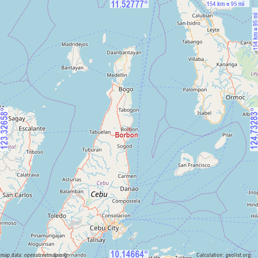
Borbon GPS coordinates[2]
10° 50' 16.8" North, 124° 1' 46.92" East
| Map corner | latitude | longitude |
|---|---|---|
| Upper-left | 11.52777°, | 123.32658° |
| Center: | 10.838°, | 124.0297° |
| Lower-right: | 10.14664°, | 124.73283° |
| Map W x H: | 153.6×153.6 km | = 95.4×95.4mi |
| max Lat: | 20.78733° ⇑58.9% North |
| Borbon: | 10.838° |
| min Lat: | ⇓41.1% South 4.65442° |
| min Long | Borbon | max Long |
| 117.04868° | 124.0297° | 126.58417° |
| W 71.7%⇐ | ⇒28.3% E |
Elevation
Elevation of Borbon is 17 m = 56 ft, and this is 70.9 m = 233 ft below average elevation for this country.
| Max E: |
2262 m = 7421 ft | 59.2% |
| Avg. | 87.9 m = 288 ft | |
| Borbon | 17 m = 56 ft | |
Min E: |
-2 m = -7 ft | 40.8% |
See also: Philippines elevation on elevation.city.
Geographical zone
Borbon is located in North Torrid zone (between Equator and Tropic of Cancer). Distance of Equator is 1205.1 km =748.8 mi to South.| Distance of | km | miles | from Borbon |
|---|---|---|---|
| North Pole | 8802 | 5469.3 | to North |
| Arctic Circle | 6196.1 | 3850.1 | to North |
| Tropic Cancer | 1400.8 | 870.4 | to North |
| Equator | 1205.1 | 748.8 | to South |


Nearby cities:
15 places around Borbon: (largest is in red/bold)
• Cabalawan
13.7 km =8.5 mi,  218°
218°
• Calumboyan
5.2 km =3.2 mi,  182°
182°
• Campusong
2.5 km =1.6 mi,  173°
173°
• Catmon
13.9 km =8.6 mi,  193°
193°
• Catmondaan
16.9 km =10.5 mi, 185°
• Damolog
7.7 km =4.8 mi,  199°
199°
• Ilihan
9.9 km =6.2 mi,  319°
319°
• Lugo
5.3 km =3.3 mi,  243°
243°
• Macaas
15.6 km =9.7 mi, 187°
• Maravilla
16.6 km =10.3 mi,  294°
294°
• Sogod
10.4 km =6.5 mi, 201°
• Tabogon
11.5 km =7.1 mi,  359°
359°
• Tabonok
16.8 km =10.4 mi,  275°
275°
• Tabunok
7 km =4.3 mi, 192°
• Taytayan
7.3 km =4.5 mi,  308°
308°
Sources, notices
• [Note1] Compared only with cities in Philippines existing in our database
• [Src1] Map data: © OpenStreetMap contributors (CC-BY-SA)
• [Src2] Other city data from geonames.org with taken over terms of usage.
• [Src3] Geographical zone / Annual Mean Temperature by Robert A. Rohde @ Wikipedia
