Calumboyan geodata
Calumboyan (Central Visayas) is a populated place; located in Philippines in Asia/Manila (GMT+8) time zone. With population of 2,339 people, there are 3586 cities with bigger population in this country. Compared to other cities in Philippines, 59.6% of cities are located further ↑North; 71.6% of cities are located further ←West and 51.8% of cities have higher elevation than Calumboyan. Note1


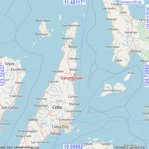
Calumboyan GPS coordinates[2]
10° 47' 28.644" North, 124° 1' 38.964" East
| Map corner | latitude | longitude |
|---|---|---|
| Upper-left | 11.48117°, | 123.32437° |
| Center: | 10.79129°, | 124.02749° |
| Lower-right: | 10.09982°, | 124.73062° |
| Map W x H: | 153.6×153.6 km | = 95.4×95.4mi |
| max Lat: | 20.78733° ⇑59.6% North |
| Calumboyan: | 10.79129° |
| min Lat: | ⇓40.4% South 4.65442° |
| min Long | Calumboyan | max Long |
| 117.04868° | 124.02749° | 126.58417° |
| W 71.6%⇐ | ⇒28.4% E |
Elevation
Elevation of Calumboyan is 22 m = 72 ft, and this is 65.9 m = 216 ft below average elevation for this country.
| Max E: |
2262 m = 7421 ft | 51.8% |
| Avg. | 87.9 m = 288 ft | |
| Calumboyan | 22 m = 72 ft | |
Min E: |
-2 m = -7 ft | 48.2% |
See also: Philippines elevation on elevation.city.
Geographical zone
Calumboyan is located in North Torrid zone (between Equator and Tropic of Cancer). Distance of Equator is 1199.9 km =745.6 mi to South.| Distance of | km | miles | from Calumboyan |
|---|---|---|---|
| North Pole | 8807.2 | 5472.5 | to North |
| Arctic Circle | 6201.3 | 3853.3 | to North |
| Tropic Cancer | 1406 | 873.6 | to North |
| Equator | 1199.9 | 745.6 | to South |


Nearby cities:
15 places around Calumboyan: (largest is in red/bold)
• Borbon
5.2 km =3.2 mi,  2°
2°
• Cabalawan
9.9 km =6.2 mi,  235°
235°
• Campusong
2.8 km =1.7 mi,  10°
10°
• Catmon
8.8 km =5.5 mi,  199°
199°
• Catmondaan
11.7 km =7.3 mi,  186°
186°
• Damolog
3.1 km =1.9 mi,  228°
228°
• Ilihan
14.1 km =8.8 mi,  333°
333°
• Lugo
5.3 km =3.3 mi,  302°
302°
• Macaas
10.4 km =6.5 mi, 189°
• Panalipan
15.9 km =9.9 mi,  182°
182°
• Sogod
5.7 km =3.5 mi,  218°
218°
• Tabogon
16.7 km =10.4 mi, 0°
• Tabuelan
17.6 km =10.9 mi,  280°
280°
• Tabunok
2 km =1.2 mi, 217°
• Taytayan
11.2 km =7 mi, 330°
Sources, notices
• [Note1] Compared only with cities in Philippines existing in our database
• [Src1] Map data: © OpenStreetMap contributors (CC-BY-SA)
• [Src2] Other city data from geonames.org with taken over terms of usage.
• [Src3] Geographical zone / Annual Mean Temperature by Robert A. Rohde @ Wikipedia
