Sogod geodata
Sogod (Central Visayas) is a seat of a third-order administrative division; located in Philippines in Asia/Manila (GMT+8) time zone. With population of 2,968 people, there are 2568 cities with bigger population in this country. Compared to other cities in Philippines, 60.1% of cities are located further ↑North; 70.8% of cities are located further ←West and 72.4% of cities have lower elevation than Sogod. Note1


Sogod GPS coordinates[2]
10° 45' 2.988" North, 123° 59' 40.992" East
| Map corner | latitude | longitude |
|---|---|---|
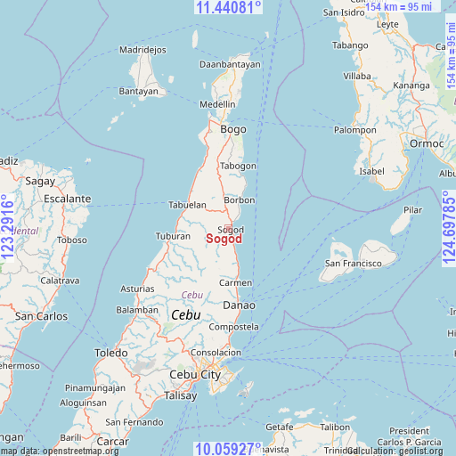
| Upper-left | 11.44081°, | 123.2916° |
| Center: | 10.75083°, | 123.99472° |
| Lower-right: | 10.05927°, | 124.69785° |
| Map W x H: | 153.6×153.6 km | = 95.4×95.4mi |
| max Lat: | 20.78733° ⇑60.1% North |
| Sogod: | 10.75083° |
| min Lat: | ⇓39.9% South 4.65442° |
| min Long | Sogod | max Long |
| 117.04868° | 123.99472° | 126.58417° |
| W 70.8%⇐ | ⇒29.2% E |
Elevation
Elevation of Sogod is 59 m = 194 ft, and this is 28.9 m = 95 ft below average elevation for this country.
| Max E: |
2262 m = 7421 ft | 27.6% |
| Avg. | 87.9 m = 288 ft | |
| Sogod | 59 m = 194 ft | |
Min E: |
-2 m = -7 ft | 72.4% |
See also: Philippines elevation on elevation.city.
Geographical zone
Sogod is located in North Torrid zone (between Equator and Tropic of Cancer). Distance of Equator is 1195.4 km =742.8 mi to South.| Distance of | km | miles | from Sogod |
|---|---|---|---|
| North Pole | 8811.7 | 5475.3 | to North |
| Arctic Circle | 6205.8 | 3856.1 | to North |
| Tropic Cancer | 1410.5 | 876.4 | to North |
| Equator | 1195.4 | 742.8 | to South |


Nearby cities:
15 places around Sogod: (largest is in red/bold)
• Borbon
10.4 km =6.5 mi,  21°
21°
• Cabalawan
4.7 km =2.9 mi,  257°
257°
• Calumboyan
5.7 km =3.5 mi,  38°
38°
• Campusong
8.3 km =5.2 mi,  29°
29°
• Catmon
3.8 km =2.4 mi,  171°
171°
• Catmondaan
7.4 km =4.6 mi,  162°
162°
• Damolog
2.7 km =1.7 mi, 27°
• Lugo
7.4 km =4.6 mi,  352°
352°
• Macaas
6.1 km =3.8 mi, 162°
• Panalipan
11.8 km =7.3 mi, 165°
• Putat
16.6 km =10.3 mi,  283°
283°
• Tabonok
17.1 km =10.6 mi,  310°
310°
• Tabuelan
15.8 km =9.8 mi,  299°
299°
• Tabunok
3.7 km =2.3 mi, 38°
• Taytayan
14.3 km =8.9 mi, 352°
Sources, notices
• [Note1] Compared only with cities in Philippines existing in our database
• [Src1] Map data: © OpenStreetMap contributors (CC-BY-SA)
• [Src2] Other city data from geonames.org with taken over terms of usage.
• [Src3] Geographical zone / Annual Mean Temperature by Robert A. Rohde @ Wikipedia
