Tantangan geodata
Tantangan (Soccsksargen) is a seat of a third-order administrative division; located in Philippines in Asia/Manila (GMT+8) time zone. With population of 10,337 people, there are 592 cities with bigger population in this country. Compared to other cities in Philippines, 94.8% of cities are located further ↑North; 83.2% of cities are located further ←West and 62.9% of cities have lower elevation than Tantangan. Note1
Administrative division(s):
- Level 1: Soccsksargen
- Level 2: Province of South Cotabato
- Level 3: Tantangan


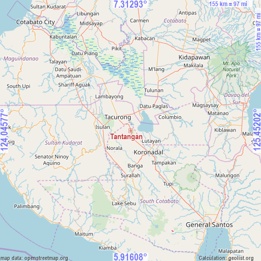
Tantangan GPS coordinates[2]
6° 36' 54" North, 124° 44' 56.004" East
| Map corner | latitude | longitude |
|---|---|---|
| Upper-left | 7.31293°, | 124.04577° |
| Center: | 6.615°, | 124.74889° |
| Lower-right: | 5.91608°, | 125.45202° |
| Map W x H: | 155.3×155.3 km | = 96.5×96.5mi |
| max Lat: | 20.78733° ⇑94.8% North |
| Tantangan: | 6.615° |
| min Lat: | ⇓5.2% South 4.65442° |
| min Long | Tantangan | max Long |
| 117.04868° | 124.74889° | 126.58417° |
| W 83.2%⇐ | ⇒16.8% E |
Elevation
Elevation of Tantangan is 38 m = 125 ft, and this is 49.9 m = 164 ft below average elevation for this country.
| Max E: |
2262 m = 7421 ft | 37.1% |
| Avg. | 87.9 m = 288 ft | |
| Tantangan | 38 m = 125 ft | |
Min E: |
-2 m = -7 ft | 62.9% |
See also: Philippines elevation on elevation.city.
Geographical zone
Tantangan is located in North Torrid zone (between Equator and Tropic of Cancer). Distance of Equator is 735.5 km =457 mi to South.| Distance of | km | miles | from Tantangan |
|---|---|---|---|
| North Pole | 9271.5 | 5761 | to North |
| Arctic Circle | 6665.7 | 4141.9 | to North |
| Tropic Cancer | 1870.4 | 1162.2 | to North |
| Equator | 735.5 | 457 | to South |


Nearby cities:
15 places around Tantangan: (largest is in red/bold)
• Bayasong
14.2 km =8.8 mi,  74°
74°
• Bukay Pait
6.3 km =3.9 mi,  161°
161°
• Buluan
13.1 km =8.1 mi,  26°
26°
• Damawato
10.2 km =6.3 mi,  21°
21°
• Dumaguil
10.6 km =6.6 mi,  273°
273°
• Kalandagan
7.5 km =4.7 mi,  339°
339°
• Kudanding
13.2 km =8.2 mi,  256°
256°
• Libas
11.2 km =7 mi, 160°
• Maibu
7 km =4.3 mi,  135°
135°
• Maindang
11.2 km =7 mi,  104°
104°
• New Iloilo
8.7 km =5.4 mi,  149°
149°
• Norala
14.3 km =8.9 mi,  223°
223°
• Paitan
14.5 km =9 mi, 69°
• President Quirino
10 km =6.2 mi,  352°
352°
• Tacurong
11.8 km =7.3 mi,  317°
317°
Sources, notices
• [Note1] Compared only with cities in Philippines existing in our database
• [Src1] Map data: © OpenStreetMap contributors (CC-BY-SA)
• [Src2] Other city data from geonames.org with taken over terms of usage.
• [Src3] Geographical zone / Annual Mean Temperature by Robert A. Rohde @ Wikipedia
