Tacurong geodata
Tacurong (Soccsksargen) is a seat of a third-order administrative division; located in Philippines in Asia/Manila (GMT+8) time zone. With population of 54,648 people, there are 168 cities with bigger population in this country. Compared to other cities in Philippines, 94.1% of cities are located further ↑North; 82.1% of cities are located further ←West and 68% of cities have lower elevation than Tacurong. Note1
Administrative division(s):
- Level 1: Soccsksargen
- Level 2: Province of Sultan Kudarat
- Level 3: City of Tacurong


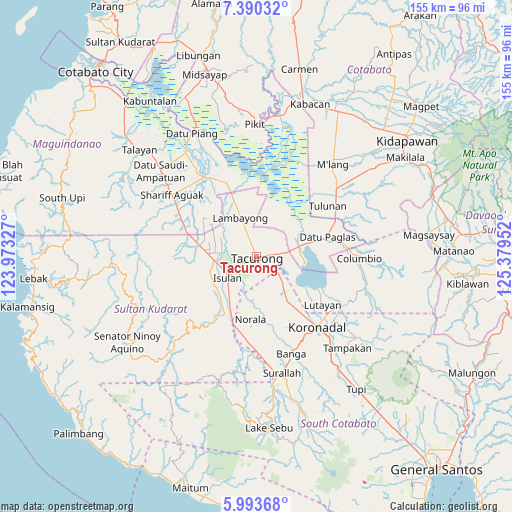
Tacurong GPS coordinates[2]
6° 41' 33" North, 124° 40' 35.004" East
| Map corner | latitude | longitude |
|---|---|---|
| Upper-left | 7.39032°, | 123.97327° |
| Center: | 6.6925°, | 124.67639° |
| Lower-right: | 5.99368°, | 125.37952° |
| Map W x H: | 155.3×155.3 km | = 96.5×96.5mi |
| max Lat: | 20.78733° ⇑94.1% North |
| Tacurong: | 6.6925° |
| min Lat: | ⇓5.9% South 4.65442° |
| min Long | Tacurong | max Long |
| 117.04868° | 124.67639° | 126.58417° |
| W 82.1%⇐ | ⇒17.9% E |
Elevation
Elevation of Tacurong is 48 m = 157 ft, and this is 39.9 m = 131 ft below average elevation for this country.
| Max E: |
2262 m = 7421 ft | 32% |
| Avg. | 87.9 m = 288 ft | |
| Tacurong | 48 m = 157 ft | |
Min E: |
-2 m = -7 ft | 68% |
See also: Tacurong elevation on elevation.city.
Geographical zone
Tacurong is located in North Torrid zone (between Equator and Tropic of Cancer). Distance of Equator is 744.1 km =462.4 mi to South.| Distance of | km | miles | from Tacurong |
|---|---|---|---|
| North Pole | 9262.9 | 5755.7 | to North |
| Arctic Circle | 6657 | 4136.5 | to North |
| Tropic Cancer | 1861.8 | 1156.9 | to North |
| Equator | 744.1 | 462.4 | to South |


Nearby cities:
15 places around Tacurong: (largest is in red/bold)
• Damawato
11.8 km =7.3 mi,  85°
85°
• Dansuli
11.9 km =7.4 mi,  240°
240°
• Dumaguil
8.5 km =5.3 mi,  197°
197°
• Gansing
3.8 km =2.4 mi,  318°
318°
• Isulan
10.6 km =6.6 mi,  228°
228°
• Kalandagan
5.6 km =3.5 mi,  106°
106°
• Kapingkong
5.9 km =3.7 mi,  250°
250°
• Katico
9.7 km =6 mi,  39°
39°
• Mamali
9.6 km =6 mi,  340°
340°
• Mariano Marcos
4.7 km =2.9 mi,  346°
346°
• Matiompong
12.2 km =7.6 mi,  271°
271°
• New Lagao
4 km =2.5 mi,  285°
285°
• President Quirino
6.8 km =4.2 mi,  79°
79°
• Tambak
6.9 km =4.3 mi,  301°
301°
• Tantangan
11.8 km =7.3 mi,  137°
137°
Sources, notices
• [Note1] Compared only with cities in Philippines existing in our database
• [Src1] Map data: © OpenStreetMap contributors (CC-BY-SA)
• [Src2] Other city data from geonames.org with taken over terms of usage.
• [Src3] Geographical zone / Annual Mean Temperature by Robert A. Rohde @ Wikipedia
