Cortes geodata
Cortes (Caraga) is a seat of a third-order administrative division; located in Philippines in Asia/Manila (GMT+8) time zone. With population of 3,026 people, there are 2496 cities with bigger population in this country. Compared to other cities in Philippines, 74% of cities are located further ↑North; 99% of cities are located further ←West and 69.6% of cities have lower elevation than Cortes. Note1


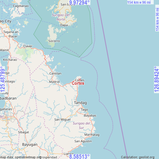
Cortes GPS coordinates[2]
9° 16' 46.992" North, 126° 11' 27.996" East
| Map corner | latitude | longitude |
|---|---|---|
| Upper-left | 9.97294°, | 125.48799° |
| Center: | 9.27972°, | 126.19111° |
| Lower-right: | 8.58513°, | 126.89424° |
| Map W x H: | 154.3×154.3 km | = 95.9×95.9mi |
| max Lat: | 20.78733° ⇑74% North |
| Cortes: | 9.27972° |
| min Lat: | ⇓26% South 4.65442° |
| min Long | Cortes | max Long |
| 117.04868° | 126.19111° | 126.58417° |
| W 99%⇐ | ⇒1% E |
Elevation
Elevation of Cortes is 51 m = 167 ft, and this is 36.9 m = 121 ft below average elevation for this country.
| Max E: |
2262 m = 7421 ft | 30.4% |
| Avg. | 87.9 m = 288 ft | |
| Cortes | 51 m = 167 ft | |
Min E: |
-2 m = -7 ft | 69.6% |
See also: Philippines elevation on elevation.city.
Geographical zone
Cortes is located in North Torrid zone (between Equator and Tropic of Cancer). Distance of Equator is 1031.8 km =641.1 mi to South.| Distance of | km | miles | from Cortes |
|---|---|---|---|
| North Pole | 8975.3 | 5577 | to North |
| Arctic Circle | 6369.4 | 3957.8 | to North |
| Tropic Cancer | 1574.1 | 978.1 | to North |
| Equator | 1031.8 | 641.1 | to South |


Nearby cities:
15 places around Cortes: (largest is in red/bold)
• Buenavista
18.6 km =11.6 mi,  190°
190°
• Burgos
1.5 km =0.9 mi, 191°
• Cantilan
24.2 km =15 mi,  284°
284°
• Carmen
20 km =12.4 mi,  252°
252°
• Carrascal
28.4 km =17.6 mi,  290°
290°
• Gamut
30.7 km =19.1 mi,  184°
184°
• La Paz
33.7 km =20.9 mi,  166°
166°
• Lanuza
14.8 km =9.2 mi, 249°
• Mabahin
10.7 km =6.6 mi, 192°
• Madrid
25 km =15.5 mi,  265°
265°
• Panikian
28.8 km =17.9 mi, 281°
• Parang
27.3 km =17 mi, 270°
• Tago
29.1 km =18.1 mi, 171°
• Tandag
22.4 km =13.9 mi, 177°
• Tigao
8 km =5 mi, 191°
Sources, notices
• [Note1] Compared only with cities in Philippines existing in our database
• [Src1] Map data: © OpenStreetMap contributors (CC-BY-SA)
• [Src2] Other city data from geonames.org with taken over terms of usage.
• [Src3] Geographical zone / Annual Mean Temperature by Robert A. Rohde @ Wikipedia
