San Luis geodata
San Luis (Caraga) is a populated place; located in Philippines in Asia/Manila (GMT+8) time zone. With population of 7,109 people, there are 882 cities with bigger population in this country. Compared to other cities in Philippines, 79% of cities are located further ↑North; 96.2% of cities are located further ←West and 60.8% of cities have higher elevation than San Luis. Note1


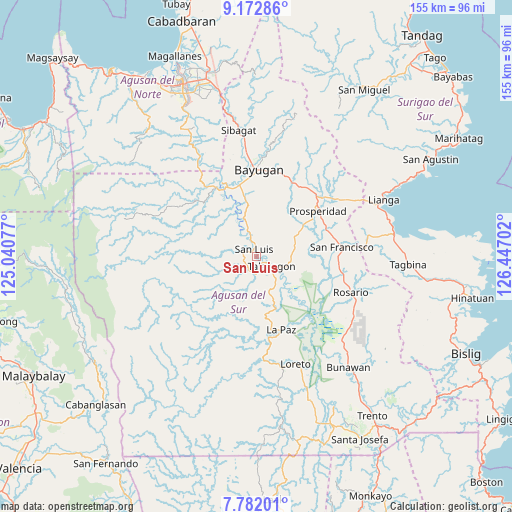
San Luis GPS coordinates[2]
8° 28' 41.016" North, 125° 44' 38.004" East
| Map corner | latitude | longitude |
|---|---|---|
| Upper-left | 9.17286°, | 125.04077° |
| Center: | 8.47806°, | 125.74389° |
| Lower-right: | 7.78201°, | 126.44702° |
| Map W x H: | 154.6×154.7 km | = 96.1×96.1mi |
| max Lat: | 20.78733° ⇑79% North |
| San Luis: | 8.47806° |
| min Lat: | ⇓21% South 4.65442° |
| min Long | San Luis | max Long |
| 117.04868° | 125.74389° | 126.58417° |
| W 96.2%⇐ | ⇒3.8% E |
Elevation
Elevation of San Luis is 16 m = 52 ft, and this is 71.9 m = 236 ft below average elevation for this country.
| Max E: |
2262 m = 7421 ft | 60.8% |
| Avg. | 87.9 m = 288 ft | |
| San Luis | 16 m = 52 ft | |
Min E: |
-2 m = -7 ft | 39.2% |
See also: Philippines elevation on elevation.city.
Geographical zone
San Luis is located in North Torrid zone (between Equator and Tropic of Cancer). Distance of Equator is 942.7 km =585.8 mi to South.| Distance of | km | miles | from San Luis |
|---|---|---|---|
| North Pole | 9064.4 | 5632.4 | to North |
| Arctic Circle | 6458.5 | 4013.1 | to North |
| Tropic Cancer | 1663.2 | 1033.5 | to North |
| Equator | 942.7 | 585.8 | to South |


Nearby cities:
15 places around San Luis: (largest is in red/bold)
• Aurora
16.4 km =10.2 mi,  38°
38°
• Bah-Bah
23.6 km =14.7 mi,  52°
52°
• Binucayan
25.5 km =15.8 mi,  186°
186°
• Borbon
16.4 km =10.2 mi,  87°
87°
• Causwagan
11.1 km =6.9 mi,  107°
107°
• Esperanza
24.5 km =15.2 mi,  334°
334°
• Guadalupe
12.3 km =7.6 mi,  341°
341°
• Kauswagan
4.3 km =2.7 mi,  8°
8°
• La Paz
23.8 km =14.8 mi,  165°
165°
• Maygatasan
25.9 km =16.1 mi,  353°
353°
• Patin-ay
22.7 km =14.1 mi,  69°
69°
• Prosperidad
20.2 km =12.6 mi,  55°
55°
• Salvacion
22.7 km =14.1 mi, 347°
• San Francisco
23.5 km =14.6 mi, 74°
• Talacogon
5.1 km =3.2 mi,  118°
118°
Sources, notices
• [Note1] Compared only with cities in Philippines existing in our database
• [Src1] Map data: © OpenStreetMap contributors (CC-BY-SA)
• [Src2] Other city data from geonames.org with taken over terms of usage.
• [Src3] Geographical zone / Annual Mean Temperature by Robert A. Rohde @ Wikipedia
