Kapangan geodata
Kapangan (Cordillera) is a seat of a third-order administrative division; located in Philippines in Asia/Manila (GMT+8) time zone. In our database, there are 4166 cities with bigger population. Compared to other cities in Philippines, 91.3% of cities are located further ↓South; 88.2% of cities are located further →East and 98.9% of cities have lower elevation than Kapangan. Note1


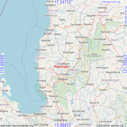
Kapangan GPS coordinates[2]
16° 34' 28.56" North, 120° 35' 49.56" East
| Map corner | latitude | longitude |
|---|---|---|
| Upper-left | 17.24732°, | 119.89398° |
| Center: | 16.5746°, | 120.5971° |
| Lower-right: | 15.89953°, | 121.30023° |
| Map W x H: | 149.9×149.9 km | = 93.1×93.1mi |
| max Lat: | 20.78733° ⇑8.7% North |
| Kapangan: | 16.5746° |
| min Lat: | ⇓91.3% South 4.65442° |
| min Long | Kapangan | max Long |
| 117.04868° | 120.5971° | 126.58417° |
| W 11.8%⇐ | ⇒88.2% E |
Elevation
Elevation of Kapangan is 951 m = 3120 ft, and this is 863.1 m = 2832 ft above average elevation for this country.
| Max E: |
2262 m = 7421 ft | 1.1% |
| Kapangan | 951 m 3120 ft | |
| Avg. | 87.9 m = 288 ft | |
Min E: |
-2 m = -7 ft | 98.9% |
See also: Philippines elevation on elevation.city.
Geographical zone
Kapangan is located in North Torrid zone (between Equator and Tropic of Cancer). Distance of this Northern Tropic circle is 763 km =474.1 mi to North.| Distance of | km | miles | from Kapangan |
|---|---|---|---|
| North Pole | 8164.1 | 5072.9 | to North |
| Arctic Circle | 5558.3 | 3453.8 | to North |
| Tropic Cancer | 763 | 474.1 | to North |
| Equator | 1842.9 | 1145.1 | to South |


Nearby cities:
15 places around Kapangan: (largest is in red/bold)
• Ambuclao
19.2 km =11.9 mi,  121°
121°
• Atok
11 km =6.8 mi,  84°
84°
• Baguio
17.6 km =10.9 mi,  181°
181°
• Bagulin
17.2 km =10.7 mi,  282°
282°
• Bayabas
16.3 km =10.1 mi,  211°
211°
• Burgos
15.6 km =9.7 mi,  246°
246°
• Dagup
17.6 km =10.9 mi,  293°
293°
• Kibungan
14.8 km =9.2 mi,  24°
24°
• La Trinidad
13.3 km =8.3 mi, 184°
• Loacan
7.9 km =4.9 mi,  110°
110°
• Sablan
14.1 km =8.8 mi,  230°
230°
• Tacadang
17.5 km =10.9 mi, 15°
• Topdac
12.4 km =7.7 mi,  99°
99°
• Tublay
3.7 km =2.3 mi,  159°
159°
• Tuding
18.8 km =11.7 mi,  165°
165°
Sources, notices
• [Note1] Compared only with cities in Philippines existing in our database
• [Src1] Map data: © OpenStreetMap contributors (CC-BY-SA)
• [Src2] Other city data from geonames.org with taken over terms of usage.
• [Src3] Geographical zone / Annual Mean Temperature by Robert A. Rohde @ Wikipedia
