Tublay geodata
Tublay (Cordillera) is a seat of a third-order administrative division; located in Philippines in Asia/Manila (GMT+8) time zone. With population of 3,706 people, there are 1918 cities with bigger population in this country. Compared to other cities in Philippines, 91.2% of cities are located further ↓South; 87.8% of cities are located further →East and 99% of cities have lower elevation than Tublay. Note1


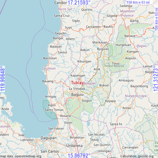
Tublay GPS coordinates[2]
16° 32' 35.16" North, 120° 36' 34.56" East
| Map corner | latitude | longitude |
|---|---|---|
| Upper-left | 17.21593°, | 119.90648° |
| Center: | 16.5431°, | 120.6096° |
| Lower-right: | 15.86792°, | 121.31273° |
| Map W x H: | 149.9×149.9 km | = 93.1×93.1mi |
| max Lat: | 20.78733° ⇑8.8% North |
| Tublay: | 16.5431° |
| min Lat: | ⇓91.2% South 4.65442° |
| min Long | Tublay | max Long |
| 117.04868° | 120.6096° | 126.58417° |
| W 12.2%⇐ | ⇒87.8% E |
Elevation
Elevation of Tublay is 971 m = 3186 ft, and this is 883.1 m = 2897 ft above average elevation for this country.
| Max E: |
2262 m = 7421 ft | 1% |
| Tublay | 971 m 3186 ft | |
| Avg. | 87.9 m = 288 ft | |
Min E: |
-2 m = -7 ft | 99% |
See also: Philippines elevation on elevation.city.
Geographical zone
Tublay is located in North Torrid zone (between Equator and Tropic of Cancer). Distance of this Northern Tropic circle is 766.5 km =476.3 mi to North.| Distance of | km | miles | from Tublay |
|---|---|---|---|
| North Pole | 8167.6 | 5075.1 | to North |
| Arctic Circle | 5561.8 | 3455.9 | to North |
| Tropic Cancer | 766.5 | 476.3 | to North |
| Equator | 1839.4 | 1142.9 | to South |


Nearby cities:
15 places around Tublay: (largest is in red/bold)
• Ambuclao
16.4 km =10.2 mi,  113°
113°
• Atok
10.6 km =6.6 mi,  64°
64°
• Baguio
14.2 km =8.8 mi,  187°
187°
• Bagulin
19.5 km =12.1 mi,  291°
291°
• Bayabas
14.3 km =8.9 mi,  223°
223°
• Burgos
15.9 km =9.9 mi,  260°
260°
• Dagup
20.4 km =12.7 mi,  300°
300°
• Kapangan
3.7 km =2.3 mi,  339°
339°
• Kibungan
17.6 km =10.9 mi,  16°
16°
• La Trinidad
10.1 km =6.3 mi, 193°
• Loacan
6.1 km =3.8 mi,  82°
82°
• Nangalisan
18.5 km =11.5 mi,  229°
229°
• Sablan
13.4 km =8.3 mi,  245°
245°
• Topdac
11 km =6.8 mi, 82°
• Tuding
15.1 km =9.4 mi,  166°
166°
Sources, notices
• [Note1] Compared only with cities in Philippines existing in our database
• [Src1] Map data: © OpenStreetMap contributors (CC-BY-SA)
• [Src2] Other city data from geonames.org with taken over terms of usage.
• [Src3] Geographical zone / Annual Mean Temperature by Robert A. Rohde @ Wikipedia
