Sulangan geodata
Sulangan (Western Visayas) is a populated place; located in Philippines in Asia/Manila (GMT+8) time zone. With population of 2,262 people, there are 3761 cities with bigger population in this country. Compared to other cities in Philippines, 59% of cities are located further ↑North; 51.6% of cities are located further →East and 80.7% of cities have higher elevation than Sulangan. Note1


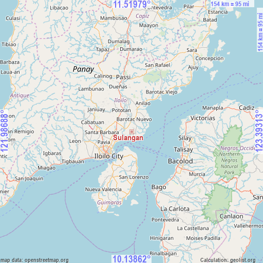
Sulangan GPS coordinates[2]
10° 49' 48" North, 122° 41' 24" East
| Map corner | latitude | longitude |
|---|---|---|
| Upper-left | 11.51979°, | 121.98688° |
| Center: | 10.83°, | 122.69° |
| Lower-right: | 10.13862°, | 123.39313° |
| Map W x H: | 153.6×153.6 km | = 95.4×95.4mi |
| max Lat: | 20.78733° ⇑59% North |
| Sulangan: | 10.83° |
| min Lat: | ⇓41% South 4.65442° |
| min Long | Sulangan | max Long |
| 117.04868° | 122.69° | 126.58417° |
| W 48.4%⇐ | ⇒51.6% E |
Elevation
Elevation of Sulangan is 9 m = 30 ft, and this is 78.9 m = 259 ft below average elevation for this country.
| Max E: |
2262 m = 7421 ft | 80.7% |
| Avg. | 87.9 m = 288 ft | |
| Sulangan | 9 m = 30 ft | |
Min E: |
-2 m = -7 ft | 19.3% |
See also: Philippines elevation on elevation.city.
Geographical zone
Sulangan is located in North Torrid zone (between Equator and Tropic of Cancer). Distance of Equator is 1204.2 km =748.3 mi to South.| Distance of | km | miles | from Sulangan |
|---|---|---|---|
| North Pole | 8802.9 | 5469.9 | to North |
| Arctic Circle | 6197 | 3850.6 | to North |
| Tropic Cancer | 1401.7 | 871 | to North |
| Equator | 1204.2 | 748.3 | to South |


Nearby cities:
15 places around Sulangan: (largest is in red/bold)
• Barotac Nuevo
7.3 km =4.5 mi,  12°
12°
• Bolilao
7.6 km =4.7 mi,  38°
38°
• Cabilauan
7.7 km =4.8 mi,  334°
334°
• Dumangas
2.6 km =1.6 mi,  102°
102°
• Ermita
8.3 km =5.2 mi,  20°
20°
• Getulio
9.6 km =6 mi,  195°
195°
• Igang
11.1 km =6.9 mi, 329°
• Jalaud
5.6 km =3.5 mi,  285°
285°
• Jalaud
9.4 km =5.8 mi, 41°
• Jamabalod
9.3 km =5.8 mi,  305°
305°
• Lucena
11.6 km =7.2 mi,  298°
298°
• Monpon
10.7 km =6.6 mi, 327°
• Pasil
8.8 km =5.5 mi,  275°
275°
• Tumcon Ilawod
10 km =6.2 mi,  345°
345°
• Zarraga
9 km =5.6 mi,  262°
262°
Sources, notices
• [Note1] Compared only with cities in Philippines existing in our database
• [Src1] Map data: © OpenStreetMap contributors (CC-BY-SA)
• [Src2] Other city data from geonames.org with taken over terms of usage.
• [Src3] Geographical zone / Annual Mean Temperature by Robert A. Rohde @ Wikipedia
