Aguisan geodata
Aguisan (Western Visayas) is a populated place; located in Philippines in Asia/Manila (GMT+8) time zone. With population of 11,798 people, there are 522 cities with bigger population in this country. Compared to other cities in Philippines, 66.6% of cities are located further ↑North; 50.8% of cities are located further ←West and 80.7% of cities have higher elevation than Aguisan. Note1
Administrative division(s):
- Level 1: Western Visayas
- Level 2: Province of Negros Occidental
- Level 3: City of Himamaylan


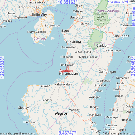
Aguisan GPS coordinates[2]
10° 9' 37.08" North, 122° 51' 41.4" East
| Map corner | latitude | longitude |
|---|---|---|
| Upper-left | 10.85163°, | 122.15838° |
| Center: | 10.1603°, | 122.8615° |
| Lower-right: | 9.46747°, | 123.56463° |
| Map W x H: | 153.9×153.9 km | = 95.6×95.6mi |
| max Lat: | 20.78733° ⇑66.6% North |
| Aguisan: | 10.1603° |
| min Lat: | ⇓33.4% South 4.65442° |
| min Long | Aguisan | max Long |
| 117.04868° | 122.8615° | 126.58417° |
| W 50.8%⇐ | ⇒49.2% E |
Elevation
Elevation of Aguisan is 9 m = 30 ft, and this is 78.9 m = 259 ft below average elevation for this country.
| Max E: |
2262 m = 7421 ft | 80.7% |
| Avg. | 87.9 m = 288 ft | |
| Aguisan | 9 m = 30 ft | |
Min E: |
-2 m = -7 ft | 19.3% |
See also: Philippines elevation on elevation.city.
Geographical zone
Aguisan is located in North Torrid zone (between Equator and Tropic of Cancer). Distance of Equator is 1129.7 km =702 mi to South.| Distance of | km | miles | from Aguisan |
|---|---|---|---|
| North Pole | 8877.3 | 5516.1 | to North |
| Arctic Circle | 6271.5 | 3896.9 | to North |
| Tropic Cancer | 1476.2 | 917.3 | to North |
| Equator | 1129.7 | 702 | to South |


Nearby cities:
15 places around Aguisan: (largest is in red/bold)
• Bagroy
9.5 km =5.9 mi,  59°
59°
• Binalbagan
3.9 km =2.4 mi,  354°
354°
• Cabadiangan
9.1 km =5.7 mi,  100°
100°
• Carabalan
11.7 km =7.3 mi,  127°
127°
• Guintubhan
12.3 km =7.6 mi, 64°
• Himamaylan
6.9 km =4.3 mi,  171°
171°
• Libacao
6.1 km =3.8 mi,  69°
69°
• Mambagatan
6.4 km =4 mi,  152°
152°
• Marawis
9.9 km =6.2 mi,  16°
16°
• Montilla
8.5 km =5.3 mi, 56°
• Nato
1.2 km =0.7 mi,  177°
177°
• Patique
9.5 km =5.9 mi,  25°
25°
• Payao
7.1 km =4.4 mi, 73°
• Suay
12.1 km =7.5 mi,  190°
190°
• Talaban
3.9 km =2.4 mi, 171°
Sources, notices
• [Note1] Compared only with cities in Philippines existing in our database
• [Src1] Map data: © OpenStreetMap contributors (CC-BY-SA)
• [Src2] Other city data from geonames.org with taken over terms of usage.
• [Src3] Geographical zone / Annual Mean Temperature by Robert A. Rohde @ Wikipedia
