Siraway geodata
Siraway (Zamboanga Peninsula) is a seat of a third-order administrative division; located in Philippines in Asia/Manila (GMT+8) time zone. With population of 4,126 people, there are 1652 cities with bigger population in this country. Compared to other cities in Philippines, 86.1% of cities are located further ↑North; 58.6% of cities are located further →East and 89.7% of cities have higher elevation than Siraway. Note1
Administrative division(s):
- Level 1: Zamboanga Peninsula
- Level 2: Province of Zamboanga del Norte
- Level 3: Sirawai


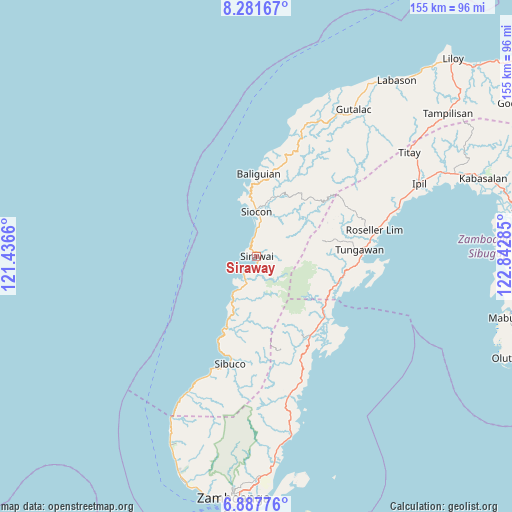
Siraway GPS coordinates[2]
7° 35' 7.008" North, 122° 8' 22.992" East
| Map corner | latitude | longitude |
|---|---|---|
| Upper-left | 8.28167°, | 121.4366° |
| Center: | 7.58528°, | 122.13972° |
| Lower-right: | 6.88776°, | 122.84285° |
| Map W x H: | 155×155 km | = 96.3×96.3mi |
| max Lat: | 20.78733° ⇑86.1% North |
| Siraway: | 7.58528° |
| min Lat: | ⇓13.9% South 4.65442° |
| min Long | Siraway | max Long |
| 117.04868° | 122.13972° | 126.58417° |
| W 41.4%⇐ | ⇒58.6% E |
Elevation
Elevation of Siraway is 7 m = 23 ft, and this is 80.9 m = 265 ft below average elevation for this country.
| Max E: |
2262 m = 7421 ft | 89.7% |
| Avg. | 87.9 m = 288 ft | |
| Siraway | 7 m = 23 ft | |
Min E: |
-2 m = -7 ft | 10.3% |
See also: Philippines elevation on elevation.city.
Geographical zone
Siraway is located in North Torrid zone (between Equator and Tropic of Cancer). Distance of Equator is 843.4 km =524.1 mi to South.| Distance of | km | miles | from Siraway |
|---|---|---|---|
| North Pole | 9163.7 | 5694.1 | to North |
| Arctic Circle | 6557.8 | 4074.8 | to North |
| Tropic Cancer | 1762.5 | 1095.2 | to North |
| Equator | 843.4 | 524.1 | to South |


Nearby cities:
15 places around Siraway: (largest is in red/bold)
• Buenavista
40.9 km =25.4 mi,  161°
161°
• Calabasa
39.1 km =24.3 mi, 164°
• Curuan
43.5 km =27 mi,  166°
166°
• Limaong
35.3 km =21.9 mi,  134°
134°
• Mangusu
32.6 km =20.3 mi,  152°
152°
• Muti
37.7 km =23.4 mi, 155°
• Roseller Lim
36.9 km =22.9 mi,  77°
77°
• Sibuco
33.7 km =20.9 mi,  194°
194°
• Sibulao
31 km =19.3 mi, 159°
• Siocon
13.4 km =8.3 mi,  357°
357°
• Tagasilay
34.1 km =21.2 mi, 157°
• Tigbao
27.1 km =16.8 mi, 130°
• Tigpalay
24.8 km =15.4 mi,  113°
113°
• Tungawan
26.9 km =16.7 mi, 108°
• Vitali
28.9 km =18 mi, 145°
Sources, notices
• [Note1] Compared only with cities in Philippines existing in our database
• [Src1] Map data: © OpenStreetMap contributors (CC-BY-SA)
• [Src2] Other city data from geonames.org with taken over terms of usage.
• [Src3] Geographical zone / Annual Mean Temperature by Robert A. Rohde @ Wikipedia
