Sibul geodata
Sibul (Central Luzon) is a populated place; located in Philippines in Asia/Manila (GMT+8) time zone. With population of 8,225 people, there are 750 cities with bigger population in this country. Compared to other cities in Philippines, 79% of cities are located further ↓South; 74.8% of cities are located further →East and 70.8% of cities have lower elevation than Sibul. Note1


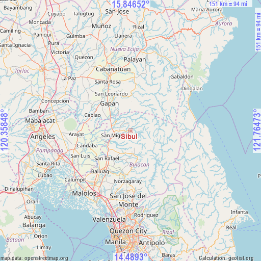
Sibul GPS coordinates[2]
15° 10' 8.4" North, 121° 3' 41.76" East
| Map corner | latitude | longitude |
|---|---|---|
| Upper-left | 15.84652°, | 120.35848° |
| Center: | 15.169°, | 121.0616° |
| Lower-right: | 14.4893°, | 121.76473° |
| Map W x H: | 150.9×150.9 km | = 93.8×93.8mi |
| max Lat: | 20.78733° ⇑21% North |
| Sibul: | 15.169° |
| min Lat: | ⇓79% South 4.65442° |
| min Long | Sibul | max Long |
| 117.04868° | 121.0616° | 126.58417° |
| W 25.2%⇐ | ⇒74.8% E |
Elevation
Elevation of Sibul is 54 m = 177 ft, and this is 33.9 m = 111 ft below average elevation for this country.
| Max E: |
2262 m = 7421 ft | 29.2% |
| Avg. | 87.9 m = 288 ft | |
| Sibul | 54 m = 177 ft | |
Min E: |
-2 m = -7 ft | 70.8% |
See also: Philippines elevation on elevation.city.
Geographical zone
Sibul is located in North Torrid zone (between Equator and Tropic of Cancer). Distance of this Northern Tropic circle is 919.3 km =571.2 mi to North.| Distance of | km | miles | from Sibul |
|---|---|---|---|
| North Pole | 8320.4 | 5170.1 | to North |
| Arctic Circle | 5714.5 | 3550.8 | to North |
| Tropic Cancer | 919.3 | 571.2 | to North |
| Equator | 1686.6 | 1048 | to South |


Nearby cities:
15 places around Sibul: (largest is in red/bold)
• Akle
13.5 km =8.4 mi,  174°
174°
• Batasan Bata
13.3 km =8.3 mi,  258°
258°
• Bulualto
13 km =8.1 mi,  296°
296°
• Calumpang
4 km =2.5 mi,  278°
278°
• Camias
9.4 km =5.8 mi,  268°
268°
• Mapaniqui
16.4 km =10.2 mi,  245°
245°
• Masalipit
3.5 km =2.2 mi,  228°
228°
• Pinambaran
9.7 km =6 mi,  292°
292°
• Pulo
16.7 km =10.4 mi, 300°
• Salapungan
14.9 km =9.3 mi, 254°
• San Ildefonso
16.2 km =10.1 mi, 232°
• San Miguel
9.7 km =6 mi, 252°
• Santa Lucia
7.5 km =4.7 mi,  307°
307°
• Tartaro
4.8 km =3 mi, 266°
• Upig
17.6 km =10.9 mi,  205°
205°
Sources, notices
• [Note1] Compared only with cities in Philippines existing in our database
• [Src1] Map data: © OpenStreetMap contributors (CC-BY-SA)
• [Src2] Other city data from geonames.org with taken over terms of usage.
• [Src3] Geographical zone / Annual Mean Temperature by Robert A. Rohde @ Wikipedia
