Camias geodata
Camias (Central Luzon) is a populated place; located in Philippines in Asia/Manila (GMT+8) time zone. With population of 7,412 people, there are 839 cities with bigger population in this country. Compared to other cities in Philippines, 79% of cities are located further ↓South; 77% of cities are located further →East and 50.3% of cities have higher elevation than Camias. Note1


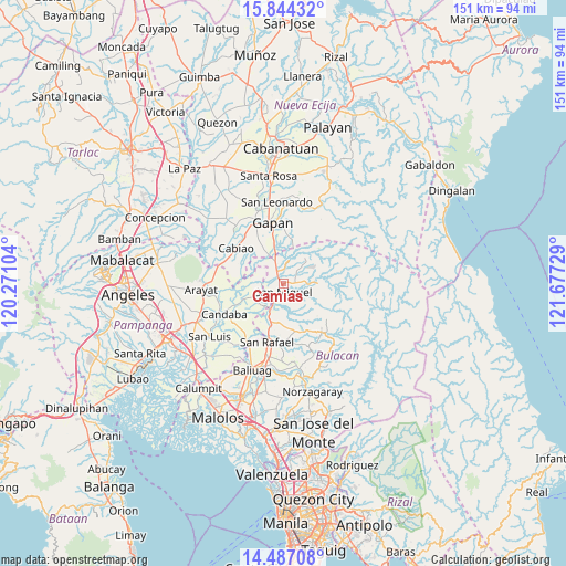
Camias GPS coordinates[2]
15° 10' 0.444" North, 120° 58' 26.976" East
| Map corner | latitude | longitude |
|---|---|---|
| Upper-left | 15.84432°, | 120.27104° |
| Center: | 15.16679°, | 120.97416° |
| Lower-right: | 14.48708°, | 121.67729° |
| Map W x H: | 150.9×150.9 km | = 93.8×93.8mi |
| max Lat: | 20.78733° ⇑21% North |
| Camias: | 15.16679° |
| min Lat: | ⇓79% South 4.65442° |
| min Long | Camias | max Long |
| 117.04868° | 120.97416° | 126.58417° |
| W 23%⇐ | ⇒77% E |
Elevation
Elevation of Camias is 23 m = 75 ft, and this is 64.9 m = 213 ft below average elevation for this country.
| Max E: |
2262 m = 7421 ft | 50.3% |
| Avg. | 87.9 m = 288 ft | |
| Camias | 23 m = 75 ft | |
Min E: |
-2 m = -7 ft | 49.7% |
See also: Philippines elevation on elevation.city.
Geographical zone
Camias is located in North Torrid zone (between Equator and Tropic of Cancer). Distance of this Northern Tropic circle is 919.5 km =571.4 mi to North.| Distance of | km | miles | from Camias |
|---|---|---|---|
| North Pole | 8320.7 | 5170.2 | to North |
| Arctic Circle | 5714.8 | 3551 | to North |
| Tropic Cancer | 919.5 | 571.4 | to North |
| Equator | 1686.4 | 1047.9 | to South |


Nearby cities:
15 places around Camias: (largest is in red/bold)
• Batasan Bata
4.4 km =2.7 mi,  235°
235°
• Bulualto
6.5 km =4 mi,  339°
339°
• Calumpang
5.5 km =3.4 mi,  81°
81°
• Mandili
10.5 km =6.5 mi,  277°
277°
• Mangga
11.6 km =7.2 mi,  322°
322°
• Mapaniqui
8.6 km =5.3 mi,  219°
219°
• Masalipit
7.1 km =4.4 mi,  107°
107°
• Pinambaran
4 km =2.5 mi,  5°
5°
• Pulo
10.1 km =6.3 mi,  330°
330°
• Salapungan
6.2 km =3.9 mi,  233°
233°
• San Ildefonso
10.2 km =6.3 mi,  200°
200°
• San Miguel
2.7 km =1.7 mi,  176°
176°
• Santa Lucia
5.9 km =3.7 mi,  35°
35°
• Sibul
9.4 km =5.8 mi,  88°
88°
• Tartaro
4.6 km =2.9 mi, 90°
Sources, notices
• [Note1] Compared only with cities in Philippines existing in our database
• [Src1] Map data: © OpenStreetMap contributors (CC-BY-SA)
• [Src2] Other city data from geonames.org with taken over terms of usage.
• [Src3] Geographical zone / Annual Mean Temperature by Robert A. Rohde @ Wikipedia
