Akle geodata
Akle (Central Luzon) is a populated place; located in Philippines in Asia/Manila (GMT+8) time zone. With population of 3,381 people, there are 2154 cities with bigger population in this country. Compared to other cities in Philippines, 78.2% of cities are located further ↓South; 74.5% of cities are located further →East and 79.5% of cities have lower elevation than Akle. Note1
Administrative division(s):
- Level 1: Central Luzon
- Level 2: Province of Bulacan
- Level 3: San Ildefonso


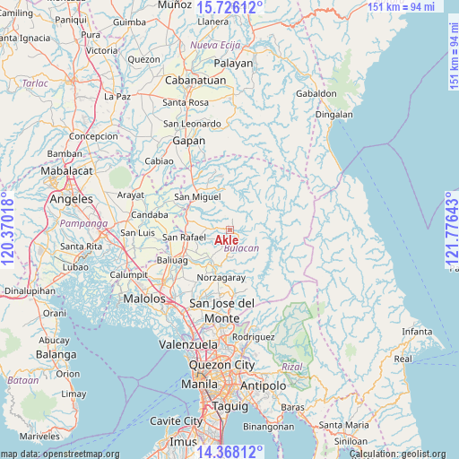
Akle GPS coordinates[2]
15° 2' 53.52" North, 121° 4' 23.88" East
| Map corner | latitude | longitude |
|---|---|---|
| Upper-left | 15.72612°, | 120.37018° |
| Center: | 15.0482°, | 121.0733° |
| Lower-right: | 14.36812°, | 121.77643° |
| Map W x H: | 151×151 km | = 93.8×93.8mi |
| max Lat: | 20.78733° ⇑21.8% North |
| Akle: | 15.0482° |
| min Lat: | ⇓78.2% South 4.65442° |
| min Long | Akle | max Long |
| 117.04868° | 121.0733° | 126.58417° |
| W 25.5%⇐ | ⇒74.5% E |
Elevation
Elevation of Akle is 89 m = 292 ft, and this is 1.1 m = 4 ft above average elevation for this country.
| Max E: |
2262 m = 7421 ft | 20.5% |
| Akle | 89 m 292 ft | |
| Avg. | 87.9 m = 288 ft | |
Min E: |
-2 m = -7 ft | 79.5% |
See also: Philippines elevation on elevation.city.
Geographical zone
Akle is located in North Torrid zone (between Equator and Tropic of Cancer). Distance of this Northern Tropic circle is 932.7 km =579.6 mi to North.| Distance of | km | miles | from Akle |
|---|---|---|---|
| North Pole | 8333.9 | 5178.4 | to North |
| Arctic Circle | 5728 | 3559.2 | to North |
| Tropic Cancer | 932.7 | 579.6 | to North |
| Equator | 1673.2 | 1039.7 | to South |


Nearby cities:
15 places around Akle: (largest is in red/bold)
• Angat
14.1 km =8.8 mi,  199°
199°
• Calumpang
14.9 km =9.3 mi,  339°
339°
• Diliman Primero
13.3 km =8.3 mi,  258°
258°
• Doña Remedios Trinidad
5.5 km =3.4 mi,  168°
168°
• Maasim
7.4 km =4.6 mi,  217°
217°
• Maguinao
15.2 km =9.4 mi, 259°
• Masalipit
11.8 km =7.3 mi, 340°
• Pulo
11.4 km =7.1 mi,  213°
213°
• Pulong Sampalok
9.8 km =6.1 mi,  187°
187°
• San Ildefonso
14.7 km =9.1 mi,  284°
284°
• San Miguel
14.8 km =9.2 mi,  314°
314°
• San Roque
15.1 km =9.4 mi,  253°
253°
• Sibul
13.5 km =8.4 mi,  354°
354°
• Tartaro
14.5 km =9 mi, 335°
• Upig
9.1 km =5.7 mi, 253°
Sources, notices
• [Note1] Compared only with cities in Philippines existing in our database
• [Src1] Map data: © OpenStreetMap contributors (CC-BY-SA)
• [Src2] Other city data from geonames.org with taken over terms of usage.
• [Src3] Geographical zone / Annual Mean Temperature by Robert A. Rohde @ Wikipedia
