Satan geodata
Satan (Autonomous Region in Muslim Mindanao) is a populated place; located in Philippines in Asia/Manila (GMT+8) time zone. With population of 4,068 people, there are 1682 cities with bigger population in this country. Compared to other cities in Philippines, 92.9% of cities are located further ↑North; 77.6% of cities are located further ←West and 83.6% of cities have lower elevation than Satan. Note1
Administrative division(s):
- Level 1: Autonomous Region in Muslim Mindanao
- Level 2: Province of Maguindanao
- Level 3: Datu Hoffer Ampatuan


Satan GPS coordinates[2]
6° 51' 47.016" North, 124° 24' 30.996" East
| Map corner | latitude | longitude |
|---|---|---|
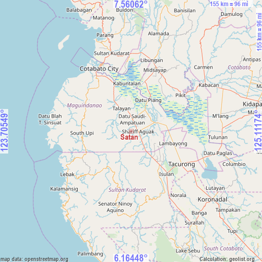
| Upper-left | 7.56062°, | 123.70549° |
| Center: | 6.86306°, | 124.40861° |
| Lower-right: | 6.16448°, | 125.11174° |
| Map W x H: | 155.2×155.2 km | = 96.4×96.4mi |
| max Lat: | 20.78733° ⇑92.9% North |
| Satan: | 6.86306° |
| min Lat: | ⇓7.1% South 4.65442° |
| min Long | Satan | max Long |
| 117.04868° | 124.40861° | 126.58417° |
| W 77.6%⇐ | ⇒22.4% E |
Elevation
Elevation of Satan is 122 m = 400 ft, and this is 34.1 m = 112 ft above average elevation for this country.
| Max E: |
2262 m = 7421 ft | 16.4% |
| Satan | 122 m 400 ft | |
| Avg. | 87.9 m = 288 ft | |
Min E: |
-2 m = -7 ft | 83.6% |
See also: Philippines elevation on elevation.city.
Geographical zone
Satan is located in North Torrid zone (between Equator and Tropic of Cancer). Distance of Equator is 763.1 km =474.2 mi to South.| Distance of | km | miles | from Satan |
|---|---|---|---|
| North Pole | 9244 | 5744 | to North |
| Arctic Circle | 6638.1 | 4124.7 | to North |
| Tropic Cancer | 1842.8 | 1145.1 | to North |
| Equator | 763.1 | 474.2 | to South |


Nearby cities:
15 places around Satan: (largest is in red/bold)
• Ampatuan
6.4 km =4 mi,  86°
86°
• Bagan
7.1 km =4.4 mi,  10°
10°
• Dalican
11.6 km =7.2 mi,  355°
355°
• Damabalas
20.6 km =12.8 mi,  34°
34°
• Esperanza
19.8 km =12.3 mi,  141°
141°
• Kauran
10.2 km =6.3 mi, 138°
• Kitango
10.1 km =6.3 mi,  20°
20°
• Kitapak
10.2 km =6.3 mi, 10°
• Maganoy
3.7 km =2.3 mi, 87°
• Mileb
19.7 km =12.2 mi,  78°
78°
• Pagatin
14.3 km =8.9 mi, 31°
• Pamantingan
16.8 km =10.4 mi,  190°
190°
• Sampao
20.7 km =12.9 mi, 85°
• Talayan
13.4 km =8.3 mi,  347°
347°
• Tapikan
9.6 km =6 mi,  262°
262°
Sources, notices
• [Note1] Compared only with cities in Philippines existing in our database
• [Src1] Map data: © OpenStreetMap contributors (CC-BY-SA)
• [Src2] Other city data from geonames.org with taken over terms of usage.
• [Src3] Geographical zone / Annual Mean Temperature by Robert A. Rohde @ Wikipedia
