Pamantingan geodata
Pamantingan (Soccsksargen) is a populated place; located in Philippines in Asia/Manila (GMT+8) time zone. With population of 2,776 people, there are 2830 cities with bigger population in this country. Compared to other cities in Philippines, 93.8% of cities are located further ↑North; 77% of cities are located further ←West and 98.8% of cities have lower elevation than Pamantingan. Note1
Administrative division(s):
- Level 1: Soccsksargen
- Level 2: Province of Sultan Kudarat
- Level 3: Esperanza


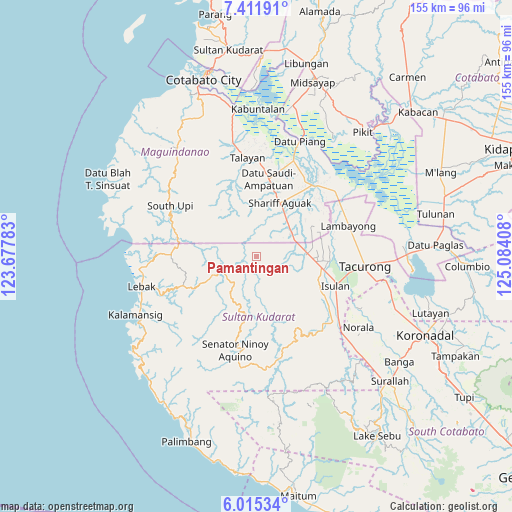
Pamantingan GPS coordinates[2]
6° 42' 50.868" North, 124° 22' 51.42" East
| Map corner | latitude | longitude |
|---|---|---|
| Upper-left | 7.41191°, | 123.67783° |
| Center: | 6.71413°, | 124.38095° |
| Lower-right: | 6.01534°, | 125.08408° |
| Map W x H: | 155.3×155.3 km | = 96.5×96.5mi |
| max Lat: | 20.78733° ⇑93.8% North |
| Pamantingan: | 6.71413° |
| min Lat: | ⇓6.2% South 4.65442° |
| min Long | Pamantingan | max Long |
| 117.04868° | 124.38095° | 126.58417° |
| W 77%⇐ | ⇒23% E |
Elevation
Elevation of Pamantingan is 900 m = 2953 ft, and this is 812.1 m = 2664 ft above average elevation for this country.
| Max E: |
2262 m = 7421 ft | 1.2% |
| Pamantingan | 900 m 2953 ft | |
| Avg. | 87.9 m = 288 ft | |
Min E: |
-2 m = -7 ft | 98.8% |
See also: Philippines elevation on elevation.city.
Geographical zone
Pamantingan is located in North Torrid zone (between Equator and Tropic of Cancer). Distance of Equator is 746.5 km =463.9 mi to South.| Distance of | km | miles | from Pamantingan |
|---|---|---|---|
| North Pole | 9260.5 | 5754.2 | to North |
| Arctic Circle | 6654.6 | 4135 | to North |
| Tropic Cancer | 1859.4 | 1155.4 | to North |
| Equator | 746.5 | 463.9 | to South |


Nearby cities:
15 places around Pamantingan: (largest is in red/bold)
• Ampatuan
19.4 km =12.1 mi,  29°
29°
• Bagan
23.9 km =14.9 mi,  10°
10°
• Biwang
21.6 km =13.4 mi,  123°
123°
• Dansuli
23.7 km =14.7 mi,  110°
110°
• Dukay
20.1 km =12.5 mi, 105°
• Esperanza
15.4 km =9.6 mi,  86°
86°
• Kauran
13.3 km =8.3 mi,  47°
47°
• Laguilayan
16.6 km =10.3 mi, 106°
• Maganoy
18 km =11.2 mi,  21°
21°
• Matiompong
20.5 km =12.7 mi,  95°
95°
• New Panay
20 km =12.4 mi,  80°
80°
• Sagasa
22.3 km =13.9 mi,  72°
72°
• Satan
16.8 km =10.4 mi, 10°
• Tapikan
16.6 km =10.3 mi,  337°
337°
• Villamor
15.4 km =9.6 mi, 94°
Sources, notices
• [Note1] Compared only with cities in Philippines existing in our database
• [Src1] Map data: © OpenStreetMap contributors (CC-BY-SA)
• [Src2] Other city data from geonames.org with taken over terms of usage.
• [Src3] Geographical zone / Annual Mean Temperature by Robert A. Rohde @ Wikipedia
