Maganoy geodata
Maganoy (Autonomous Region in Muslim Mindanao) is a seat of a third-order administrative division; located in Philippines in Asia/Manila (GMT+8) time zone. With population of 17,394 people, there are 401 cities with bigger population in this country. Compared to other cities in Philippines, 92.8% of cities are located further ↑North; 78.1% of cities are located further ←West and 60.9% of cities have lower elevation than Maganoy. Note1
Administrative division(s):
- Level 1: Autonomous Region in Muslim Mindanao
- Level 2: Province of Maguindanao
- Level 3: Shariff Aguak (Maganoy)


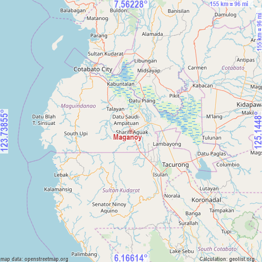
Maganoy GPS coordinates[2]
6° 51' 52.992" North, 124° 26' 30.012" East
| Map corner | latitude | longitude |
|---|---|---|
| Upper-left | 7.56228°, | 123.73855° |
| Center: | 6.86472°, | 124.44167° |
| Lower-right: | 6.16614°, | 125.1448° |
| Map W x H: | 155.2×155.2 km | = 96.4×96.4mi |
| max Lat: | 20.78733° ⇑92.8% North |
| Maganoy: | 6.86472° |
| min Lat: | ⇓7.2% South 4.65442° |
| min Long | Maganoy | max Long |
| 117.04868° | 124.44167° | 126.58417° |
| W 78.1%⇐ | ⇒21.9% E |
Elevation
Elevation of Maganoy is 35 m = 115 ft, and this is 52.9 m = 174 ft below average elevation for this country.
| Max E: |
2262 m = 7421 ft | 39.1% |
| Avg. | 87.9 m = 288 ft | |
| Maganoy | 35 m = 115 ft | |
Min E: |
-2 m = -7 ft | 60.9% |
See also: Philippines elevation on elevation.city.
Geographical zone
Maganoy is located in North Torrid zone (between Equator and Tropic of Cancer). Distance of Equator is 763.3 km =474.3 mi to South.| Distance of | km | miles | from Maganoy |
|---|---|---|---|
| North Pole | 9243.8 | 5743.8 | to North |
| Arctic Circle | 6637.9 | 4124.6 | to North |
| Tropic Cancer | 1842.6 | 1144.9 | to North |
| Equator | 763.3 | 474.3 | to South |


Nearby cities:
15 places around Maganoy: (largest is in red/bold)
• Ampatuan
2.8 km =1.7 mi,  85°
85°
• Bagan
7.2 km =4.5 mi,  340°
340°
• Barurao
17.6 km =10.9 mi,  77°
77°
• Dalican
12.2 km =7.6 mi, 337°
• Esperanza
18 km =11.2 mi,  151°
151°
• Kauran
8.4 km =5.2 mi,  157°
157°
• Kitango
9.3 km =5.8 mi,  359°
359°
• Kitapak
10 km =6.2 mi,  349°
349°
• Mileb
16.1 km =10 mi, 76°
• Pagatin
12.6 km =7.8 mi,  17°
17°
• Sagasa
17.8 km =11.1 mi,  124°
124°
• Sampao
17 km =10.6 mi, 85°
• Satan
3.7 km =2.3 mi,  267°
267°
• Talayan
14.5 km =9 mi,  332°
332°
• Tapikan
13.2 km =8.2 mi,  263°
263°
Sources, notices
• [Note1] Compared only with cities in Philippines existing in our database
• [Src1] Map data: © OpenStreetMap contributors (CC-BY-SA)
• [Src2] Other city data from geonames.org with taken over terms of usage.
• [Src3] Geographical zone / Annual Mean Temperature by Robert A. Rohde @ Wikipedia
