San Juan geodata
San Juan (Central Luzon) is a populated place; located in Philippines in Asia/Manila (GMT+8) time zone. With population of 3,514 people, there are 2045 cities with bigger population in this country. Compared to other cities in Philippines, 77.8% of cities are located further ↓South; 85.5% of cities are located further →East and 80.7% of cities have higher elevation than San Juan. Note1
Administrative division(s):
- Level 1: Central Luzon
- Level 2: Province of Pampanga
- Level 3: City of San Fernando


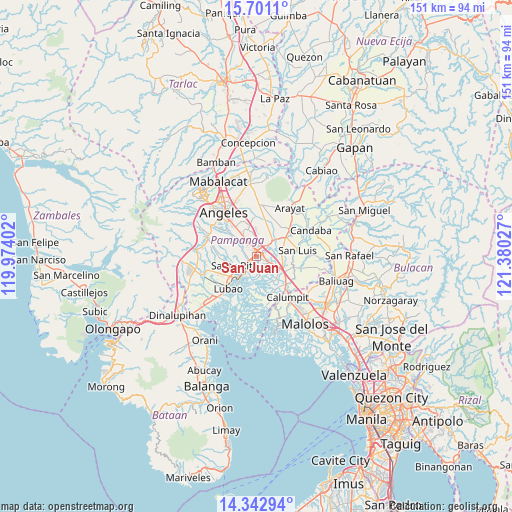
San Juan GPS coordinates[2]
15° 1' 23.16" North, 120° 40' 37.704" East
| Map corner | latitude | longitude |
|---|---|---|
| Upper-left | 15.7011°, | 119.97402° |
| Center: | 15.0231°, | 120.67714° |
| Lower-right: | 14.34294°, | 121.38027° |
| Map W x H: | 151×151 km | = 93.8×93.8mi |
| max Lat: | 20.78733° ⇑22.2% North |
| San Juan: | 15.0231° |
| min Lat: | ⇓77.8% South 4.65442° |
| min Long | San Juan | max Long |
| 117.04868° | 120.67714° | 126.58417° |
| W 14.5%⇐ | ⇒85.5% E |
Elevation
Elevation of San Juan is 9 m = 30 ft, and this is 78.9 m = 259 ft below average elevation for this country.
| Max E: |
2262 m = 7421 ft | 80.7% |
| Avg. | 87.9 m = 288 ft | |
| San Juan | 9 m = 30 ft | |
Min E: |
-2 m = -7 ft | 19.3% |
See also: Philippines elevation on elevation.city.
Geographical zone
San Juan is located in North Torrid zone (between Equator and Tropic of Cancer). Distance of this Northern Tropic circle is 935.5 km =581.3 mi to North.| Distance of | km | miles | from San Juan |
|---|---|---|---|
| North Pole | 8336.6 | 5180.1 | to North |
| Arctic Circle | 5730.8 | 3561 | to North |
| Tropic Cancer | 935.5 | 581.3 | to North |
| Equator | 1670.4 | 1037.9 | to South |


Nearby cities:
15 places around San Juan: (largest is in red/bold)
• Bacolor
3.7 km =2.3 mi,  226°
226°
• Bulaon
6.8 km =4.2 mi,  346°
346°
• Del Pilar
2.8 km =1.7 mi,  58°
58°
• Guagua
8 km =5 mi,  216°
216°
• Laug
8.4 km =5.2 mi,  71°
71°
• Lourdes
6.3 km =3.9 mi,  173°
173°
• Magliman
2 km =1.2 mi,  314°
314°
• Mexico
6.5 km =4 mi,  44°
44°
• Minalin
6.2 km =3.9 mi, 174°
• Pau
5.1 km =3.2 mi,  83°
83°
• San Agustin
8.5 km =5.3 mi,  244°
244°
• San Carlos
9.4 km =5.8 mi, 78°
• San Fernando
1.5 km =0.9 mi,  32°
32°
• Santa Rita
7.5 km =4.7 mi,  249°
249°
• Santo Domingo
8 km =5 mi,  116°
116°
Sources, notices
• [Note1] Compared only with cities in Philippines existing in our database
• [Src1] Map data: © OpenStreetMap contributors (CC-BY-SA)
• [Src2] Other city data from geonames.org with taken over terms of usage.
• [Src3] Geographical zone / Annual Mean Temperature by Robert A. Rohde @ Wikipedia
