Calamba geodata
Calamba (Calabarzon) is a seat of a first-order administrative division; located in Philippines in Asia/Manila (GMT+8) time zone. With population of 316,612 people, there are 25 cities with bigger population in this country. Compared to other cities in Philippines, 72% of cities are located further ↓South; 72.2% of cities are located further →East and 60.8% of cities have higher elevation than Calamba. Note1
Administrative division(s):
- Level 1: Calabarzon
- Level 2: Province of Laguna
- Level 3: City of Calamba


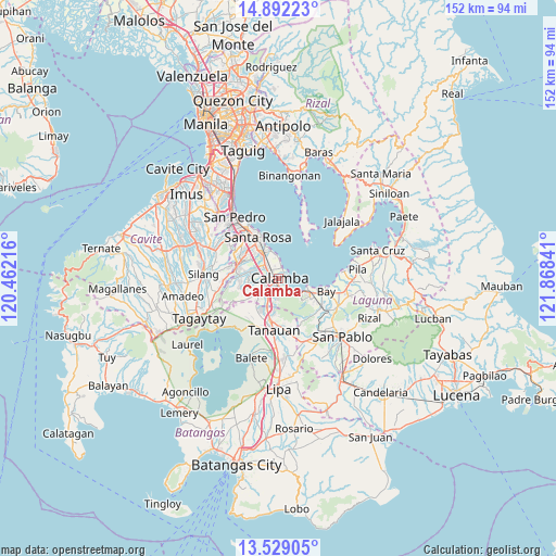
Calamba GPS coordinates[2]
14° 12' 42.012" North, 121° 9' 55.008" East
| Map corner | latitude | longitude |
|---|---|---|
| Upper-left | 14.89223°, | 120.46216° |
| Center: | 14.21167°, | 121.16528° |
| Lower-right: | 13.52905°, | 121.86841° |
| Map W x H: | 151.6×151.6 km | = 94.2×94.2mi |
| max Lat: | 20.78733° ⇑28% North |
| Calamba: | 14.21167° |
| min Lat: | ⇓72% South 4.65442° |
| min Long | Calamba | max Long |
| 117.04868° | 121.16528° | 126.58417° |
| W 27.8%⇐ | ⇒72.2% E |
Elevation
Elevation of Calamba is 16 m = 52 ft, and this is 71.9 m = 236 ft below average elevation for this country.
| Max E: |
2262 m = 7421 ft | 60.8% |
| Avg. | 87.9 m = 288 ft | |
| Calamba | 16 m = 52 ft | |
Min E: |
-2 m = -7 ft | 39.2% |
See also: Calamba elevation on elevation.city.
Geographical zone
Calamba is located in North Torrid zone (between Equator and Tropic of Cancer). Distance of this Northern Tropic circle is 1025.7 km =637.3 mi to North.| Distance of | km | miles | from Calamba |
|---|---|---|---|
| North Pole | 8426.9 | 5236.2 | to North |
| Arctic Circle | 5821 | 3617 | to North |
| Tropic Cancer | 1025.7 | 637.3 | to North |
| Equator | 1580.2 | 981.9 | to South |


Nearby cities:
15 places around Calamba: (largest is in red/bold)
• Aplaya
13.4 km =8.3 mi,  335°
335°
• Bay
13.3 km =8.3 mi,  103°
103°
• Bilog-Bilog
13.7 km =8.5 mi,  217°
217°
• Bitin
12.2 km =7.6 mi,  150°
150°
• Cabuyao
8 km =5 mi,  328°
328°
• Los Baños
9.4 km =5.8 mi,  119°
119°
• Mamatid
2.7 km =1.7 mi,  345°
345°
• Masaya
14.2 km =8.8 mi, 117°
• Pantay Na Matanda
11.5 km =7.1 mi,  204°
204°
• Prinza
3.5 km =2.2 mi,  240°
240°
• Pulong Santa Cruz
11.8 km =7.3 mi,  305°
305°
• Santa Rosa
12.6 km =7.8 mi, 332°
• Santo Tomas
11.8 km =7.3 mi,  192°
192°
• Santor
14.3 km =8.9 mi,  205°
205°
• Tanauan
14 km =8.7 mi, 186°
Sources, notices
• [Note1] Compared only with cities in Philippines existing in our database
• [Src1] Map data: © OpenStreetMap contributors (CC-BY-SA)
• [Src2] Other city data from geonames.org with taken over terms of usage.
• [Src3] Geographical zone / Annual Mean Temperature by Robert A. Rohde @ Wikipedia
