Santa Praxedes geodata
Santa Praxedes (Cagayan Valley) is a seat of a third-order administrative division; located in Philippines in Asia/Manila (GMT+8) time zone. In our database, there are 4166 cities with bigger population. Compared to other cities in Philippines, 99.8% of cities are located further ↓South; 76.4% of cities are located further →East and 92% of cities have lower elevation than Santa Praxedes. Note1
Administrative division(s):
- Level 1: Cagayan Valley
- Level 2: Province of Cagayan
- Level 3: Santa Praxedes


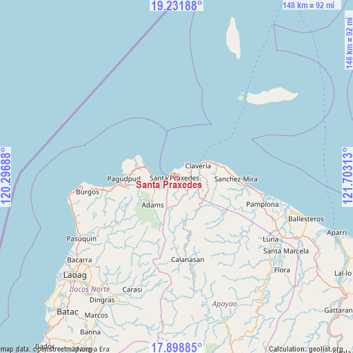
Santa Praxedes GPS coordinates[2]
18° 34' 0.012" North, 121° 0' 0" East
| Map corner | latitude | longitude |
|---|---|---|
| Upper-left | 19.23188°, | 120.29688° |
| Center: | 18.56667°, | 121° |
| Lower-right: | 17.89885°, | 121.70313° |
| Map W x H: | 148.2×148.2 km | = 92.1×92.1mi |
| max Lat: | 20.78733° ⇑0.2% North |
| Santa Praxedes: | 18.56667° |
| min Lat: | ⇓99.8% South 4.65442° |
| min Long | Santa Praxedes | max Long |
| 117.04868° | 121° | 126.58417° |
| W 23.6%⇐ | ⇒76.4% E |
Elevation
Elevation of Santa Praxedes is 285 m = 935 ft, and this is 197.1 m = 647 ft above average elevation for this country.
| Max E: |
2262 m = 7421 ft | 8% |
| Santa Praxedes | 285 m 935 ft | |
| Avg. | 87.9 m = 288 ft | |
Min E: |
-2 m = -7 ft | 92% |
See also: Philippines elevation on elevation.city.
Geographical zone
Santa Praxedes is located in North Torrid zone (between Equator and Tropic of Cancer). Distance of this Northern Tropic circle is 541.5 km =336.5 mi to North.| Distance of | km | miles | from Santa Praxedes |
|---|---|---|---|
| North Pole | 7942.6 | 4935.3 | to North |
| Arctic Circle | 5336.8 | 3316.1 | to North |
| Tropic Cancer | 541.5 | 336.5 | to North |
| Equator | 2064.4 | 1282.8 | to South |


Nearby cities:
15 places around Santa Praxedes: (largest is in red/bold)
• Adams
15.3 km =9.5 mi,  223°
223°
• Bagu
40.7 km =25.3 mi,  112°
112°
• Bangui
24.8 km =15.4 mi,  262°
262°
• Burgos
37.8 km =23.5 mi, 261°
• Calanasan
34.8 km =21.6 mi,  174°
174°
• Calog Norte
46.5 km =28.9 mi,  119°
119°
• Carasi
43.2 km =26.8 mi,  198°
198°
• Claveria
9.9 km =6.2 mi,  62°
62°
• Davila
45.9 km =28.5 mi, 256°
• Dumalneg
20.6 km =12.8 mi, 257°
• Luna
45.9 km =28.5 mi,  125°
125°
• Namuac
18.1 km =11.2 mi,  74°
74°
• Pagudpud
22.5 km =14 mi,  268°
268°
• Pamplona
37.7 km =23.4 mi, 107°
• Santa Cruz
33.2 km =20.6 mi,  99°
99°
Sources, notices
• [Note1] Compared only with cities in Philippines existing in our database
• [Src1] Map data: © OpenStreetMap contributors (CC-BY-SA)
• [Src2] Other city data from geonames.org with taken over terms of usage.
• [Src3] Geographical zone / Annual Mean Temperature by Robert A. Rohde @ Wikipedia
