Davila geodata
Davila (Ilocos) is a populated place; located in Philippines in Asia/Manila (GMT+8) time zone. With population of 3,465 people, there are 2088 cities with bigger population in this country. Compared to other cities in Philippines, 99.7% of cities are located further ↓South; 88.9% of cities are located further →East and 73.2% of cities have higher elevation than Davila. Note1


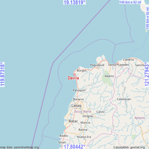
Davila GPS coordinates[2]
18° 28' 21.36" North, 120° 34' 34.68" East
| Map corner | latitude | longitude |
|---|---|---|
| Upper-left | 19.13819°, | 119.87318° |
| Center: | 18.4726°, | 120.5763° |
| Lower-right: | 17.80442°, | 121.27943° |
| Map W x H: | 148.3×148.3 km | = 92.1×92.1mi |
| max Lat: | 20.78733° ⇑0.3% North |
| Davila: | 18.4726° |
| min Lat: | ⇓99.7% South 4.65442° |
| min Long | Davila | max Long |
| 117.04868° | 120.5763° | 126.58417° |
| W 11.1%⇐ | ⇒88.9% E |
Elevation
Elevation of Davila is 11 m = 36 ft, and this is 76.9 m = 252 ft below average elevation for this country.
| Max E: |
2262 m = 7421 ft | 73.2% |
| Avg. | 87.9 m = 288 ft | |
| Davila | 11 m = 36 ft | |
Min E: |
-2 m = -7 ft | 26.8% |
See also: Philippines elevation on elevation.city.
Geographical zone
Davila is located in North Torrid zone (between Equator and Tropic of Cancer). Distance of this Northern Tropic circle is 552 km =343 mi to North.| Distance of | km | miles | from Davila |
|---|---|---|---|
| North Pole | 7953.1 | 4941.8 | to North |
| Arctic Circle | 5347.2 | 3322.6 | to North |
| Tropic Cancer | 552 | 343 | to North |
| Equator | 2054 | 1276.3 | to South |


Nearby cities:
15 places around Davila: (largest is in red/bold)
• Adams
34.1 km =21.2 mi,  91°
91°
• Baay
39.3 km =24.4 mi,  180°
180°
• Bacarra
24.7 km =15.3 mi,  171°
171°
• Bangui
21.4 km =13.3 mi,  70°
70°
• Burgos
8.7 km =5.4 mi,  55°
55°
• Dumalneg
25.3 km =15.7 mi,  76°
76°
• Laoag
30.6 km =19 mi, 176°
• Nagbacalan
40.1 km =24.9 mi,  188°
188°
• Pagudpud
24.3 km =15.1 mi, 65°
• Pasuquin
16.1 km =10 mi,  164°
164°
• Piddig
37.3 km =23.2 mi, 156°
• San Lorenzo
38.3 km =23.8 mi, 171°
• San Nicolas
33.4 km =20.8 mi, 176°
• Sarrat
35.8 km =22.2 mi, 167°
• Vintar
28.2 km =17.5 mi, 164°
Sources, notices
• [Note1] Compared only with cities in Philippines existing in our database
• [Src1] Map data: © OpenStreetMap contributors (CC-BY-SA)
• [Src2] Other city data from geonames.org with taken over terms of usage.
• [Src3] Geographical zone / Annual Mean Temperature by Robert A. Rohde @ Wikipedia
