Burgos geodata
Burgos (Ilocos) is a seat of a third-order administrative division; located in Philippines in Asia/Manila (GMT+8) time zone. In our database, there are 4166 cities with bigger population. Compared to other cities in Philippines, 99.7% of cities are located further ↓South; 86.7% of cities are located further →East and 73.8% of cities have lower elevation than Burgos. Note1


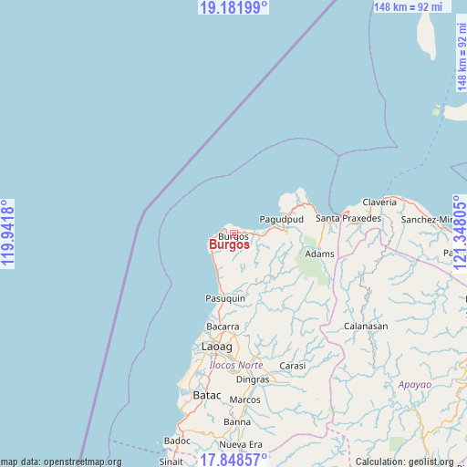
Burgos GPS coordinates[2]
18° 30' 59.688" North, 120° 38' 41.712" East
| Map corner | latitude | longitude |
|---|---|---|
| Upper-left | 19.18199°, | 119.9418° |
| Center: | 18.51658°, | 120.64492° |
| Lower-right: | 17.84857°, | 121.34805° |
| Map W x H: | 148.3×148.3 km | = 92.1×92.1mi |
| max Lat: | 20.78733° ⇑0.3% North |
| Burgos: | 18.51658° |
| min Lat: | ⇓99.7% South 4.65442° |
| min Long | Burgos | max Long |
| 117.04868° | 120.64492° | 126.58417° |
| W 13.3%⇐ | ⇒86.7% E |
Elevation
Elevation of Burgos is 64 m = 210 ft, and this is 23.9 m = 78 ft below average elevation for this country.
| Max E: |
2262 m = 7421 ft | 26.2% |
| Avg. | 87.9 m = 288 ft | |
| Burgos | 64 m = 210 ft | |
Min E: |
-2 m = -7 ft | 73.8% |
See also: Philippines elevation on elevation.city.
Geographical zone
Burgos is located in North Torrid zone (between Equator and Tropic of Cancer). Distance of this Northern Tropic circle is 547.1 km =340 mi to North.| Distance of | km | miles | from Burgos |
|---|---|---|---|
| North Pole | 7948.2 | 4938.8 | to North |
| Arctic Circle | 5342.3 | 3319.6 | to North |
| Tropic Cancer | 547.1 | 340 | to North |
| Equator | 2058.9 | 1279.3 | to South |


Nearby cities:
15 places around Burgos: (largest is in red/bold)
• Adams
27.5 km =17.1 mi,  101°
101°
• Bacarra
29.5 km =18.3 mi,  186°
186°
• Bangui
13.1 km =8.1 mi,  79°
79°
• Carasi
42.5 km =26.4 mi,  146°
146°
• Davila
8.7 km =5.4 mi,  235°
235°
• Dumalneg
17.4 km =10.8 mi,  86°
86°
• Laoag
35.8 km =22.2 mi, 188°
• Pagudpud
15.8 km =9.8 mi,  71°
71°
• Pasuquin
20.6 km =12.8 mi, 187°
• Piddig
39.8 km =24.7 mi,  168°
168°
• San Lorenzo
42.8 km =26.6 mi,  182°
182°
• San Nicolas
38.6 km =24 mi, 187°
• Santa Praxedes
37.8 km =23.5 mi, 81°
• Sarrat
39.9 km =24.8 mi, 179°
• Vintar
32 km =19.9 mi, 179°
Sources, notices
• [Note1] Compared only with cities in Philippines existing in our database
• [Src1] Map data: © OpenStreetMap contributors (CC-BY-SA)
• [Src2] Other city data from geonames.org with taken over terms of usage.
• [Src3] Geographical zone / Annual Mean Temperature by Robert A. Rohde @ Wikipedia
