Pagudpud geodata
Pagudpud (Ilocos) is a seat of a third-order administrative division; located in Philippines in Asia/Manila (GMT+8) time zone. With population of 4,945 people, there are 1315 cities with bigger population in this country. Compared to other cities in Philippines, 99.8% of cities are located further ↓South; 82.6% of cities are located further →East and 85.4% of cities have higher elevation than Pagudpud. Note1


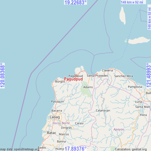
Pagudpud GPS coordinates[2]
18° 33' 41.76" North, 120° 47' 12.48" East
| Map corner | latitude | longitude |
|---|---|---|
| Upper-left | 19.22683°, | 120.08368° |
| Center: | 18.5616°, | 120.7868° |
| Lower-right: | 17.89376°, | 121.48993° |
| Map W x H: | 148.2×148.2 km | = 92.1×92.1mi |
| max Lat: | 20.78733° ⇑0.2% North |
| Pagudpud: | 18.5616° |
| min Lat: | ⇓99.8% South 4.65442° |
| min Long | Pagudpud | max Long |
| 117.04868° | 120.7868° | 126.58417° |
| W 17.4%⇐ | ⇒82.6% E |
Elevation
Elevation of Pagudpud is 8 m = 26 ft, and this is 79.9 m = 262 ft below average elevation for this country.
| Max E: |
2262 m = 7421 ft | 85.4% |
| Avg. | 87.9 m = 288 ft | |
| Pagudpud | 8 m = 26 ft | |
Min E: |
-2 m = -7 ft | 14.6% |
See also: Philippines elevation on elevation.city.
Geographical zone
Pagudpud is located in North Torrid zone (between Equator and Tropic of Cancer). Distance of this Northern Tropic circle is 542.1 km =336.8 mi to North.| Distance of | km | miles | from Pagudpud |
|---|---|---|---|
| North Pole | 7943.2 | 4935.7 | to North |
| Arctic Circle | 5337.3 | 3316.4 | to North |
| Tropic Cancer | 542.1 | 336.8 | to North |
| Equator | 2063.9 | 1282.4 | to South |


Nearby cities:
15 places around Pagudpud: (largest is in red/bold)
• Adams
15.9 km =9.9 mi,  131°
131°
• Bacarra
38.9 km =24.2 mi,  208°
208°
• Bangui
3.4 km =2.1 mi,  217°
217°
• Burgos
15.8 km =9.8 mi,  251°
251°
• Calanasan
43 km =26.7 mi,  142°
142°
• Carasi
41.2 km =25.6 mi,  167°
167°
• Claveria
31.7 km =19.7 mi,  80°
80°
• Davila
24.3 km =15.1 mi, 245°
• Dumalneg
4.7 km =2.9 mi,  149°
149°
• Laoag
45.2 km =28.1 mi, 206°
• Namuac
40.3 km =25 mi, 82°
• Pasuquin
31.1 km =19.3 mi, 215°
• Piddig
44.6 km =27.7 mi,  189°
189°
• Santa Praxedes
22.5 km =14 mi,  88°
88°
• Vintar
39.9 km =24.8 mi,  201°
201°
Sources, notices
• [Note1] Compared only with cities in Philippines existing in our database
• [Src1] Map data: © OpenStreetMap contributors (CC-BY-SA)
• [Src2] Other city data from geonames.org with taken over terms of usage.
• [Src3] Geographical zone / Annual Mean Temperature by Robert A. Rohde @ Wikipedia
