Bagu geodata
Bagu (Cagayan Valley) is a populated place; located in Philippines in Asia/Manila (GMT+8) time zone. With population of 2,120 people, there are 4043 cities with bigger population in this country. Compared to other cities in Philippines, 99.6% of cities are located further ↓South; 69.3% of cities are located further →East and 85.4% of cities have higher elevation than Bagu. Note1


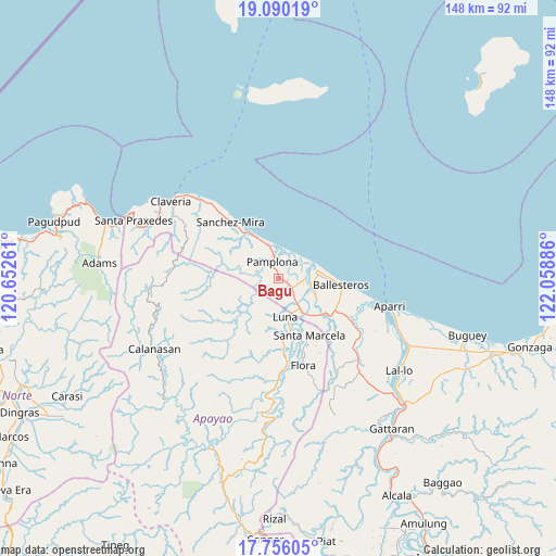
Bagu GPS coordinates[2]
18° 25' 27.876" North, 121° 21' 20.628" East
| Map corner | latitude | longitude |
|---|---|---|
| Upper-left | 19.09019°, | 120.65261° |
| Center: | 18.42441°, | 121.35573° |
| Lower-right: | 17.75605°, | 122.05886° |
| Map W x H: | 148.3×148.3 km | = 92.1×92.1mi |
| max Lat: | 20.78733° ⇑0.4% North |
| Bagu: | 18.42441° |
| min Lat: | ⇓99.6% South 4.65442° |
| min Long | Bagu | max Long |
| 117.04868° | 121.35573° | 126.58417° |
| W 30.7%⇐ | ⇒69.3% E |
Elevation
Elevation of Bagu is 8 m = 26 ft, and this is 79.9 m = 262 ft below average elevation for this country.
| Max E: |
2262 m = 7421 ft | 85.4% |
| Avg. | 87.9 m = 288 ft | |
| Bagu | 8 m = 26 ft | |
Min E: |
-2 m = -7 ft | 14.6% |
See also: Philippines elevation on elevation.city.
Geographical zone
Bagu is located in North Torrid zone (between Equator and Tropic of Cancer). Distance of this Northern Tropic circle is 557.3 km =346.3 mi to North.| Distance of | km | miles | from Bagu |
|---|---|---|---|
| North Pole | 7958.5 | 4945.2 | to North |
| Arctic Circle | 5352.6 | 3326 | to North |
| Tropic Cancer | 557.3 | 346.3 | to North |
| Equator | 2048.6 | 1272.9 | to South |


Nearby cities:
15 places around Bagu: (largest is in red/bold)
• Abulug
10.6 km =6.6 mi,  77°
77°
• Allacapan
30.6 km =19 mi,  136°
136°
• Ballesteros
16.9 km =10.5 mi,  94°
94°
• Binalan
22.7 km =14.1 mi,  118°
118°
• Cabaritan East
14 km =8.7 mi, 92°
• Calog Norte
7.4 km =4.6 mi,  155°
155°
• Flora
24.1 km =15 mi, 164°
• Guiddam
15.3 km =9.5 mi,  130°
130°
• Lucban
12.6 km =7.8 mi, 140°
• Luna
11 km =6.8 mi,  181°
181°
• Mabuttal East
17.6 km =10.9 mi,  107°
107°
• Namuac
28.8 km =17.9 mi,  315°
315°
• Pamplona
4.9 km =3 mi,  341°
341°
• Santa Cruz
11.3 km =7 mi, 335°
• Santa Marcela
17.7 km =11 mi,  152°
152°
Sources, notices
• [Note1] Compared only with cities in Philippines existing in our database
• [Src1] Map data: © OpenStreetMap contributors (CC-BY-SA)
• [Src2] Other city data from geonames.org with taken over terms of usage.
• [Src3] Geographical zone / Annual Mean Temperature by Robert A. Rohde @ Wikipedia
