Cuevas geodata
Cuevas (Caraga) is a populated place; located in Philippines in Asia/Manila (GMT+8) time zone. With population of 2,243 people, there are 3798 cities with bigger population in this country. Compared to other cities in Philippines, 82.5% of cities are located further ↑North; 98.5% of cities are located further ←West and 68.9% of cities have lower elevation than Cuevas. Note1


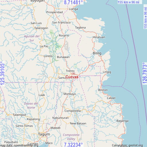
Cuevas GPS coordinates[2]
8° 1' 9.012" North, 126° 5' 39.012" East
| Map corner | latitude | longitude |
|---|---|---|
| Upper-left | 8.71481°, | 125.39105° |
| Center: | 8.01917°, | 126.09417° |
| Lower-right: | 7.32234°, | 126.7973° |
| Map W x H: | 154.8×154.8 km | = 96.2×96.2mi |
| max Lat: | 20.78733° ⇑82.5% North |
| Cuevas: | 8.01917° |
| min Lat: | ⇓17.5% South 4.65442° |
| min Long | Cuevas | max Long |
| 117.04868° | 126.09417° | 126.58417° |
| W 98.5%⇐ | ⇒1.5% E |
Elevation
Elevation of Cuevas is 50 m = 164 ft, and this is 37.9 m = 124 ft below average elevation for this country.
| Max E: |
2262 m = 7421 ft | 31.1% |
| Avg. | 87.9 m = 288 ft | |
| Cuevas | 50 m = 164 ft | |
Min E: |
-2 m = -7 ft | 68.9% |
See also: Philippines elevation on elevation.city.
Geographical zone
Cuevas is located in North Torrid zone (between Equator and Tropic of Cancer). Distance of Equator is 891.6 km =554 mi to South.| Distance of | km | miles | from Cuevas |
|---|---|---|---|
| North Pole | 9115.4 | 5664 | to North |
| Arctic Circle | 6509.5 | 4044.8 | to North |
| Tropic Cancer | 1714.3 | 1065.2 | to North |
| Equator | 891.6 | 554 | to South |


Nearby cities:
15 places around Cuevas: (largest is in red/bold)
• Babag
31.9 km =19.8 mi,  184°
184°
• Basa
6.8 km =4.2 mi,  330°
330°
• Baylo
18.7 km =11.6 mi,  193°
193°
• Bunawan
20 km =12.4 mi, 325°
• Libertad
12.3 km =7.6 mi,  322°
322°
• Loreto
32.4 km =20.1 mi,  305°
305°
• Monkayo
23.1 km =14.4 mi, 190°
• Pasian
10.6 km =6.6 mi,  196°
196°
• Salvacion
4 km =2.5 mi,  122°
122°
• Santa Josefa
7.7 km =4.8 mi,  246°
246°
• Santa Maria
7.7 km =4.8 mi,  78°
78°
• Sinubong
18.8 km =11.7 mi,  286°
286°
• Tapia
30.8 km =19.1 mi, 197°
• Trento
4.5 km =2.8 mi, 311°
• Veruela
16.4 km =10.2 mi, 291°
Sources, notices
• [Note1] Compared only with cities in Philippines existing in our database
• [Src1] Map data: © OpenStreetMap contributors (CC-BY-SA)
• [Src2] Other city data from geonames.org with taken over terms of usage.
• [Src3] Geographical zone / Annual Mean Temperature by Robert A. Rohde @ Wikipedia
