Malabuyoc geodata
Malabuyoc (Central Visayas) is a seat of a third-order administrative division; located in Philippines in Asia/Manila (GMT+8) time zone. With population of 2,812 people, there are 2774 cities with bigger population in this country. Compared to other cities in Philippines, 72.1% of cities are located further ↑North; 58.9% of cities are located further ←West and 57.6% of cities have higher elevation than Malabuyoc. Note1


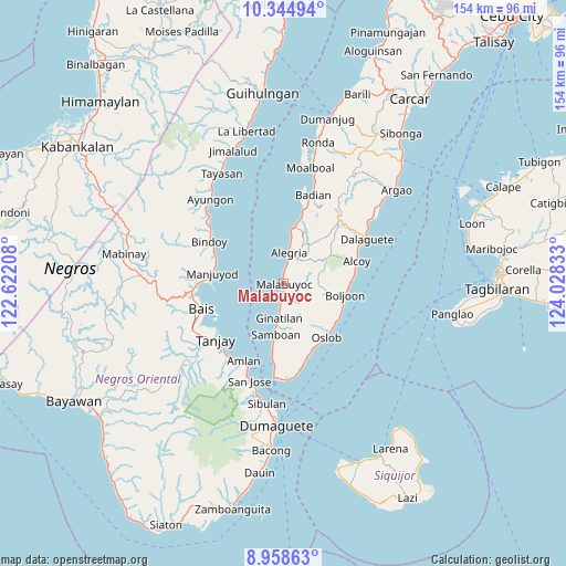
Malabuyoc GPS coordinates[2]
9° 39' 9" North, 123° 19' 30.72" East
| Map corner | latitude | longitude |
|---|---|---|
| Upper-left | 10.34494°, | 122.62208° |
| Center: | 9.6525°, | 123.3252° |
| Lower-right: | 8.95863°, | 124.02833° |
| Map W x H: | 154.1×154.1 km | = 95.8×95.8mi |
| max Lat: | 20.78733° ⇑72.1% North |
| Malabuyoc: | 9.6525° |
| min Lat: | ⇓27.9% South 4.65442° |
| min Long | Malabuyoc | max Long |
| 117.04868° | 123.3252° | 126.58417° |
| W 58.9%⇐ | ⇒41.1% E |
Elevation
Elevation of Malabuyoc is 18 m = 59 ft, and this is 69.9 m = 229 ft below average elevation for this country.
| Max E: |
2262 m = 7421 ft | 57.6% |
| Avg. | 87.9 m = 288 ft | |
| Malabuyoc | 18 m = 59 ft | |
Min E: |
-2 m = -7 ft | 42.4% |
See also: Philippines elevation on elevation.city.
Geographical zone
Malabuyoc is located in North Torrid zone (between Equator and Tropic of Cancer). Distance of Equator is 1073.3 km =666.9 mi to South.| Distance of | km | miles | from Malabuyoc |
|---|---|---|---|
| North Pole | 8933.8 | 5551.2 | to North |
| Arctic Circle | 6327.9 | 3932 | to North |
| Tropic Cancer | 1532.7 | 952.4 | to North |
| Equator | 1073.3 | 666.9 | to South |


Nearby cities:
15 places around Malabuyoc: (largest is in red/bold)
• Alegria
8.6 km =5.3 mi,  10°
10°
• Becerril
12 km =7.5 mi,  89°
89°
• Boljoon
17 km =10.6 mi,  99°
99°
• El Pardo
18.6 km =11.6 mi, 87°
• Ginatilan
9.3 km =5.8 mi,  188°
188°
• Guadalupe
11.5 km =7.1 mi,  46°
46°
• Lepanto
9.2 km =5.7 mi,  67°
67°
• Madridejos
15.6 km =9.7 mi, 8°
• Malbug
9.1 km =5.7 mi, 10°
• Montaneza
3.6 km =2.2 mi, 6°
• Nugas
13.7 km =8.5 mi, 68°
• Samboan
14 km =8.7 mi, 188°
• Santa Filomena
11.2 km =7 mi, 10°
• Talangnan
2.3 km =1.4 mi,  153°
153°
• Valencia
14 km =8.7 mi,  19°
19°
Sources, notices
• [Note1] Compared only with cities in Philippines existing in our database
• [Src1] Map data: © OpenStreetMap contributors (CC-BY-SA)
• [Src2] Other city data from geonames.org with taken over terms of usage.
• [Src3] Geographical zone / Annual Mean Temperature by Robert A. Rohde @ Wikipedia
