Jaro geodata
Jaro (Eastern Visayas) is a seat of a third-order administrative division; located in Philippines in Asia/Manila (GMT+8) time zone. With population of 7,935 people, there are 776 cities with bigger population in this country. Compared to other cities in Philippines, 54.7% of cities are located further ↑North; 83.8% of cities are located further ←West and 82.1% of cities have lower elevation than Jaro. Note1


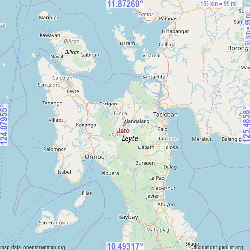
Jaro GPS coordinates[2]
11° 11' 1.5" North, 124° 46' 57.612" East
| Map corner | latitude | longitude |
|---|---|---|
| Upper-left | 11.87269°, | 124.07955° |
| Center: | 11.18375°, | 124.78267° |
| Lower-right: | 10.49317°, | 125.4858° |
| Map W x H: | 153.4×153.4 km | = 95.3×95.3mi |
| max Lat: | 20.78733° ⇑54.7% North |
| Jaro: | 11.18375° |
| min Lat: | ⇓45.3% South 4.65442° |
| min Long | Jaro | max Long |
| 117.04868° | 124.78267° | 126.58417° |
| W 83.8%⇐ | ⇒16.2% E |
Elevation
Elevation of Jaro is 107 m = 351 ft, and this is 19.1 m = 63 ft above average elevation for this country.
| Max E: |
2262 m = 7421 ft | 17.9% |
| Jaro | 107 m 351 ft | |
| Avg. | 87.9 m = 288 ft | |
Min E: |
-2 m = -7 ft | 82.1% |
See also: Philippines elevation on elevation.city.
Geographical zone
Jaro is located in North Torrid zone (between Equator and Tropic of Cancer). Distance of Equator is 1243.5 km =772.7 mi to South.| Distance of | km | miles | from Jaro |
|---|---|---|---|
| North Pole | 8763.5 | 5445.4 | to North |
| Arctic Circle | 6157.7 | 3826.2 | to North |
| Tropic Cancer | 1362.4 | 846.6 | to North |
| Equator | 1243.5 | 772.7 | to South |


Nearby cities:
15 places around Jaro: (largest is in red/bold)
• Alangalang
7.4 km =4.6 mi,  70°
70°
• Barugo
16.3 km =10.1 mi,  342°
342°
• Canhandugan
5.4 km =3.4 mi,  183°
183°
• Capoocan
19.6 km =12.2 mi,  308°
308°
• Carigara
17 km =10.6 mi,  318°
318°
• Dagami
18.9 km =11.7 mi,  136°
136°
• Guindapunan
15.7 km =9.8 mi,  327°
327°
• Lim-oo
17 km =10.6 mi,  257°
257°
• Masarayao
20.8 km =12.9 mi,  239°
239°
• Palo
22.9 km =14.2 mi,  97°
97°
• Pastrana
12.4 km =7.7 mi,  115°
115°
• Rizal
22.2 km =13.8 mi,  267°
267°
• San Miguel
10.8 km =6.7 mi,  30°
30°
• Santa Fe
14.6 km =9.1 mi,  89°
89°
• Tunga
7.7 km =4.8 mi, 333°
Sources, notices
• [Note1] Compared only with cities in Philippines existing in our database
• [Src1] Map data: © OpenStreetMap contributors (CC-BY-SA)
• [Src2] Other city data from geonames.org with taken over terms of usage.
• [Src3] Geographical zone / Annual Mean Temperature by Robert A. Rohde @ Wikipedia
