Santa Fe geodata
Santa Fe (Northern Mindanao) is a populated place; located in Philippines in Asia/Manila (GMT+8) time zone. With population of 3,380 people, there are 2156 cities with bigger population in this country. Compared to other cities in Philippines, 79.7% of cities are located further ↑North; 83.8% of cities are located further ←West and 97% of cities have lower elevation than Santa Fe. Note1
Administrative division(s):
- Level 1: Northern Mindanao
- Level 2: Province of Bukidnon
- Level 3: Libona


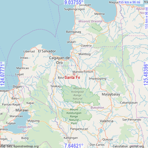
Santa Fe GPS coordinates[2]
8° 20' 33" North, 124° 46' 50.988" East
| Map corner | latitude | longitude |
|---|---|---|
| Upper-left | 9.03755°, | 124.07771° |
| Center: | 8.3425°, | 124.78083° |
| Lower-right: | 7.64621°, | 125.48396° |
| Map W x H: | 154.7×154.7 km | = 96.1×96.1mi |
| max Lat: | 20.78733° ⇑79.7% North |
| Santa Fe: | 8.3425° |
| min Lat: | ⇓20.3% South 4.65442° |
| min Long | Santa Fe | max Long |
| 117.04868° | 124.78083° | 126.58417° |
| W 83.8%⇐ | ⇒16.2% E |
Elevation
Elevation of Santa Fe is 607 m = 1991 ft, and this is 519.1 m = 1703 ft above average elevation for this country.
| Max E: |
2262 m = 7421 ft | 3% |
| Santa Fe | 607 m 1991 ft | |
| Avg. | 87.9 m = 288 ft | |
Min E: |
-2 m = -7 ft | 97% |
See also: Philippines elevation on elevation.city.
Geographical zone
Santa Fe is located in North Torrid zone (between Equator and Tropic of Cancer). Distance of Equator is 927.6 km =576.4 mi to South.| Distance of | km | miles | from Santa Fe |
|---|---|---|---|
| North Pole | 9079.5 | 5641.7 | to North |
| Arctic Circle | 6473.6 | 4022.5 | to North |
| Tropic Cancer | 1678.3 | 1042.8 | to North |
| Equator | 927.6 | 576.4 | to South |


Nearby cities:
15 places around Santa Fe: (largest is in red/bold)
• Agusan
17.1 km =10.6 mi,  343°
343°
• Alae
9.8 km =6.1 mi,  21°
21°
• Bugo
18.6 km =11.6 mi,  352°
352°
• Dalirig
13.8 km =8.6 mi,  73°
73°
• Damilag
3.7 km =2.3 mi, 68°
• Kalugmanan
11.3 km =7 mi,  129°
129°
• Libona
5 km =3.1 mi,  265°
265°
• Liboran
14.6 km =9.1 mi,  275°
275°
• Lingating
16.8 km =10.4 mi, 265°
• Mambatangan
11.6 km =7.2 mi,  29°
29°
• Manolo Fortich
9.7 km =6 mi, 71°
• Pongol
8 km =5 mi,  206°
206°
• Pontian
14.8 km =9.2 mi,  117°
117°
• Salimbalan
10 km =6.2 mi,  220°
220°
• Sankanan
9 km =5.6 mi,  109°
109°
Sources, notices
• [Note1] Compared only with cities in Philippines existing in our database
• [Src1] Map data: © OpenStreetMap contributors (CC-BY-SA)
• [Src2] Other city data from geonames.org with taken over terms of usage.
• [Src3] Geographical zone / Annual Mean Temperature by Robert A. Rohde @ Wikipedia
