Manolo Fortich geodata
Manolo Fortich (Northern Mindanao) is a seat of a third-order administrative division; located in Philippines in Asia/Manila (GMT+8) time zone. With population of 27,064 people, there are 302 cities with bigger population in this country. Compared to other cities in Philippines, 79.5% of cities are located further ↑North; 85.6% of cities are located further ←West and 96.1% of cities have lower elevation than Manolo Fortich. Note1
Administrative division(s):
- Level 1: Northern Mindanao
- Level 2: Province of Bukidnon
- Level 3: Manolo Fortich


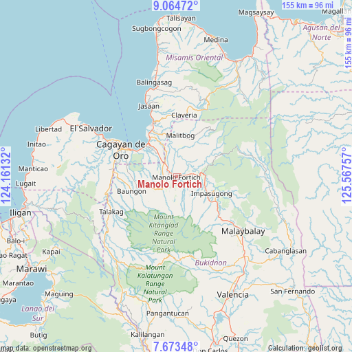
Manolo Fortich GPS coordinates[2]
8° 22' 10.992" North, 124° 51' 51.984" East
| Map corner | latitude | longitude |
|---|---|---|
| Upper-left | 9.06472°, | 124.16132° |
| Center: | 8.36972°, | 124.86444° |
| Lower-right: | 7.67348°, | 125.56757° |
| Map W x H: | 154.7×154.7 km | = 96.1×96.1mi |
| max Lat: | 20.78733° ⇑79.5% North |
| Manolo Fortich: | 8.36972° |
| min Lat: | ⇓20.5% South 4.65442° |
| min Long | Manolo Fortich | max Long |
| 117.04868° | 124.86444° | 126.58417° |
| W 85.6%⇐ | ⇒14.4% E |
Elevation
Elevation of Manolo Fortich is 515 m = 1690 ft, and this is 427.1 m = 1401 ft above average elevation for this country.
| Max E: |
2262 m = 7421 ft | 3.9% |
| Manolo Fortich | 515 m 1690 ft | |
| Avg. | 87.9 m = 288 ft | |
Min E: |
-2 m = -7 ft | 96.1% |
See also: Philippines elevation on elevation.city.
Geographical zone
Manolo Fortich is located in North Torrid zone (between Equator and Tropic of Cancer). Distance of Equator is 930.6 km =578.2 mi to South.| Distance of | km | miles | from Manolo Fortich |
|---|---|---|---|
| North Pole | 9076.4 | 5639.8 | to North |
| Arctic Circle | 6470.5 | 4020.6 | to North |
| Tropic Cancer | 1675.3 | 1041 | to North |
| Equator | 930.6 | 578.2 | to South |


Nearby cities:
15 places around Manolo Fortich: (largest is in red/bold)
• Alae
8.3 km =5.2 mi,  316°
316°
• Dalirig
4.1 km =2.5 mi,  78°
78°
• Damilag
6 km =3.7 mi,  253°
253°
• Kalugmanan
10.2 km =6.3 mi,  182°
182°
• Kisolon
13.1 km =8.1 mi,  109°
109°
• La Fortuna
18.1 km =11.2 mi,  123°
123°
• Libona
14.6 km =9.1 mi,  256°
256°
• Malitbog
18.4 km =11.4 mi,  6°
6°
• Maluko
9.9 km =6.2 mi,  86°
86°
• Mambatangan
7.9 km =4.9 mi,  334°
334°
• Pongol
16.3 km =10.1 mi,  231°
231°
• Pontian
10.6 km =6.6 mi,  158°
158°
• Sankanan
6.1 km =3.8 mi,  186°
186°
• Santa Fe
9.7 km =6 mi, 251°
• Sumilao
12.8 km =8 mi,  135°
135°
Sources, notices
• [Note1] Compared only with cities in Philippines existing in our database
• [Src1] Map data: © OpenStreetMap contributors (CC-BY-SA)
• [Src2] Other city data from geonames.org with taken over terms of usage.
• [Src3] Geographical zone / Annual Mean Temperature by Robert A. Rohde @ Wikipedia
